数据与计算发展前沿 ›› 2024, Vol. 6 ›› Issue (2): 165-176.

CSTR: 32002.14.jfdc.CN10-1649/TP.2024.02.015

doi: 10.11871/jfdc.issn.2096-742X.2024.02.015

• 技术与应用 • 上一篇    下一篇

基于钻孔数据的岩溶形态统计规律研究

彭丁茂(),舒宗运*(),郑束宁   

  1. 浙江数智交院科技股份有限公司,浙江 杭州 310030
  • 收稿日期:2023-02-22 出版日期:2024-04-20 发布日期:2024-04-26
  • 通讯作者: *舒宗运(E-mail: shuzongyun@126.com
  • 作者简介:彭丁茂,浙江数智交院科技股份有限公司(浙江省交通规划设计研究院有限公司)副总工程师,教授级高级工程师,注册土木工程师(岩土),主持或参与5项省部级科研项目及参编3部规范、指南,发表论文10余篇,取得发明专利1项,实用新型专利4项,软著3项。主要从事和研究领域为工程地质及水文地质方向。
    负责论文总体撰写及提出论文中涉及的研究方法。
    PENG Dingmao is the Deputy Chief Engineer of Zhe Jang Institute of Communications CO.LTD, a Professor-level senior engineer, and a National Registered Civil Engineer (Rock and Soil). He presided over or participated in 5 provincial and ministerial scientific research projects, and participated in the compilation of 3 specifications and guidelines. He has published more than 10 papers and obtained 1 invention patent, 4 utility model patents, and 3 Software copyrights. His main research interests include engineering geology and hydrogeology.
    In this paper, he is responsible for the overall writing of the paper and proposing the research methods involved in the paper.
    E-mail: 273226045@qq.com|舒宗运,浙江数智交院科技股份有限公司(浙江省交通规划设计研究院有限公司),助理研究员,注册土木工程师(岩土),曾参与“十三五”国家重大专项1项及省部级课题1项,发表论文10余篇,取得发明专利1项,实用新型专利6项,软著1项。主要从事和研究领域为工程地质及水文地质方向。
    负责论文结构梳理、论文修改及部分内容撰写。
    SHU Zongyun is an assistant research fellow of Zhe Jang Institute of Communications CO.LTD, and a National Registered Civil Engineer (Rock and Soil). He has participated in one major national special project and one provincial and ministerial project during the "13th Five-Year Plan". He had published more than 10 papers and obtained 1 invention patent, 6 utility model patents, and 1 Software copyright. His main research interests include engineering geology and hydrogeology.
    In this paper, he is responsible for structuring and revising the paper, as well as partial content writing.
    E-mail: shuzongyun@126.com
  • 基金资助:
    2021年度交通运输行业重点科技项目清单“新型光纤测斜系统研发与应用技术研究”(2021-MS2-062);2021年交通工程建设科研计划“新型光纤测斜系统研发与应用技术研究”(2021029)

Study on Statistical Law of Karst Morphology Based on Borehole Data

PENG Dingmao(),SHU Zongyun*(),ZHENG Shuning   

  1. Zhe Jiang Institute of communications CO.LTD, Hangzhou, Zhejiang 310030, China
  • Received:2023-02-22 Online:2024-04-20 Published:2024-04-26

摘要:

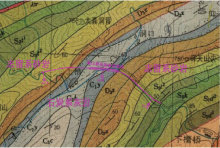
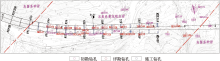
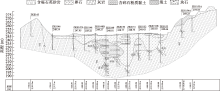
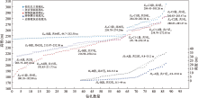
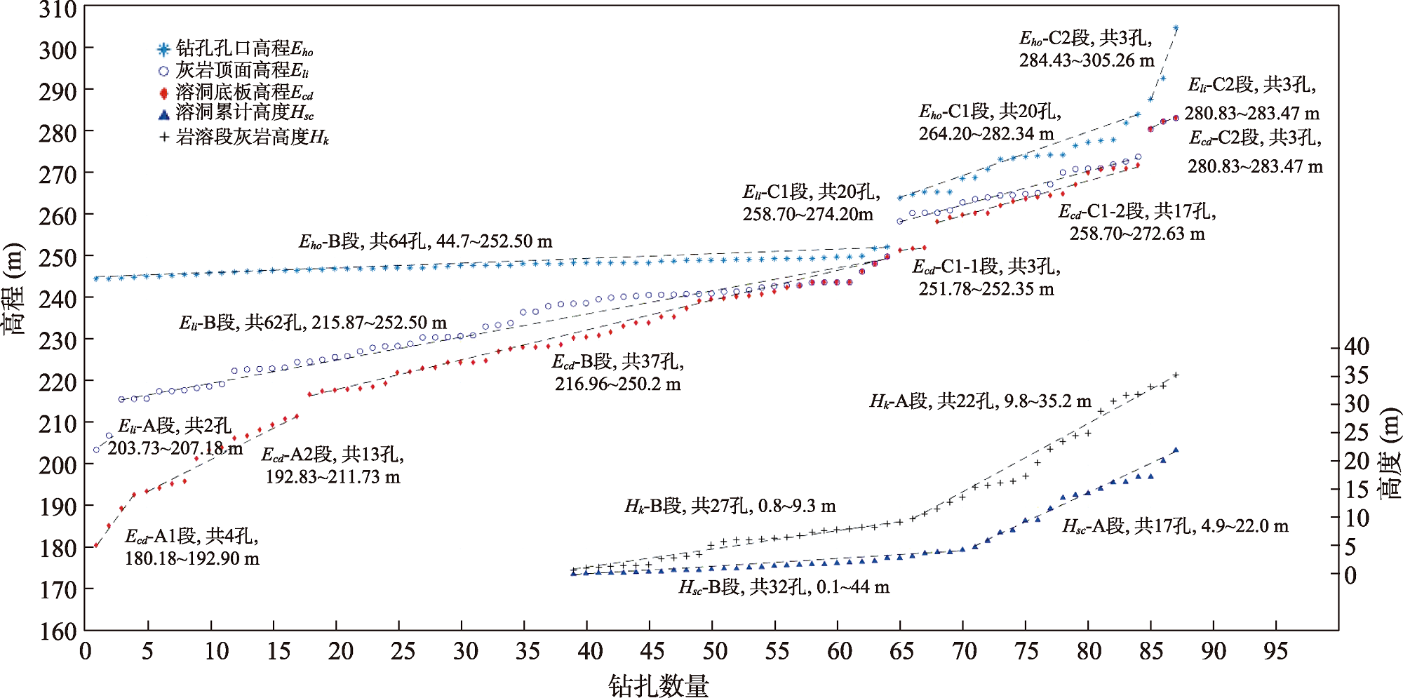
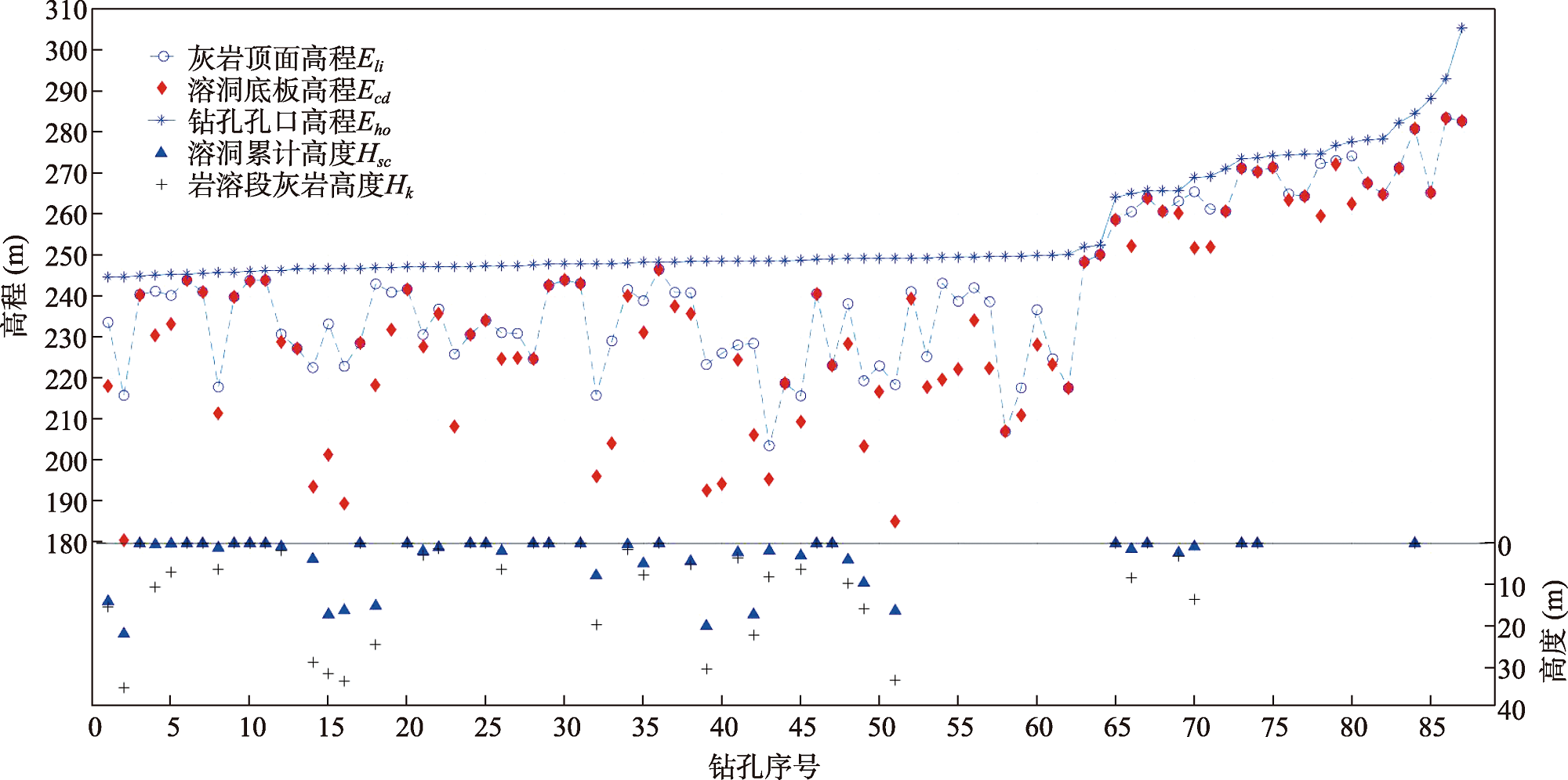
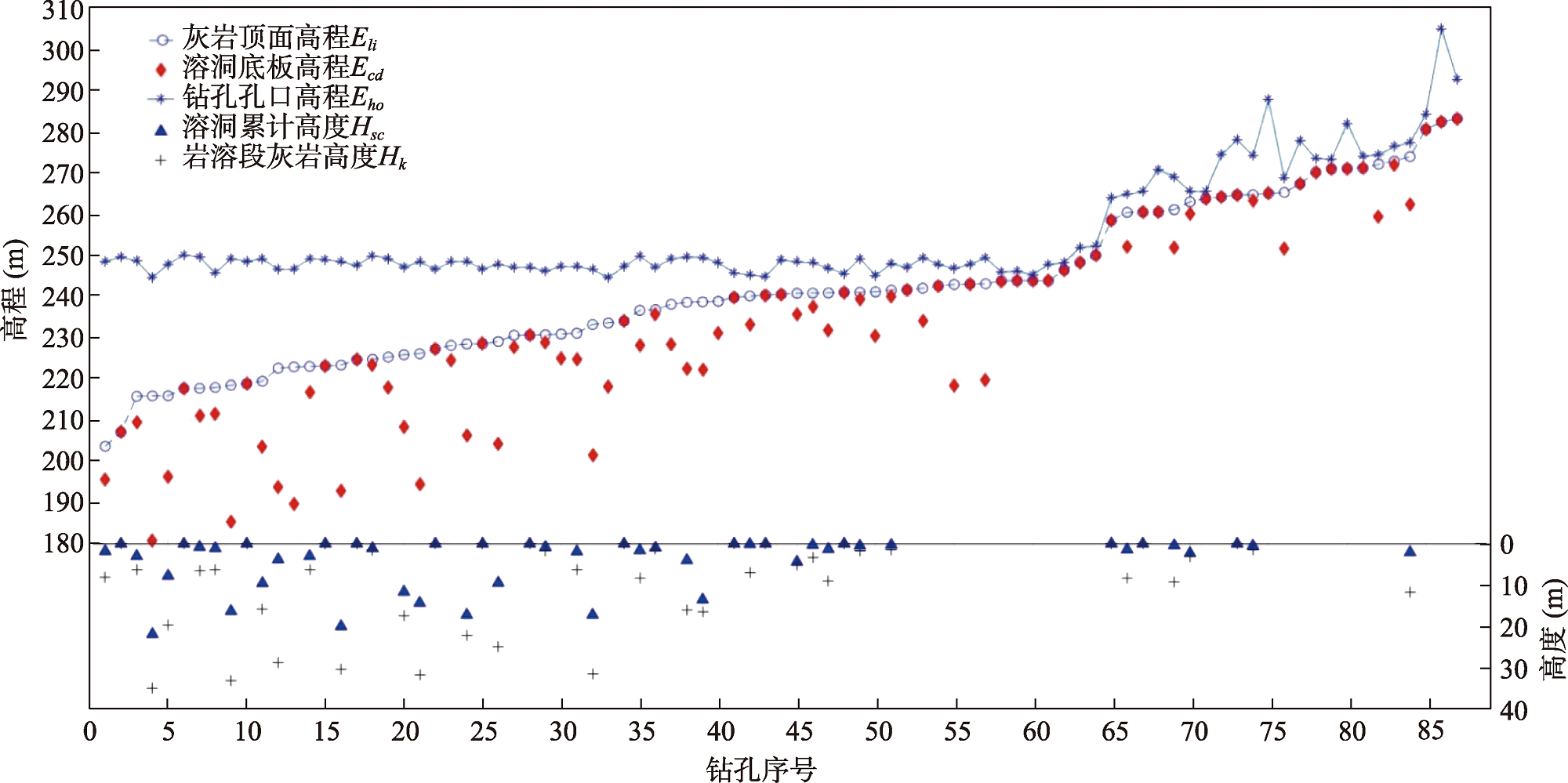
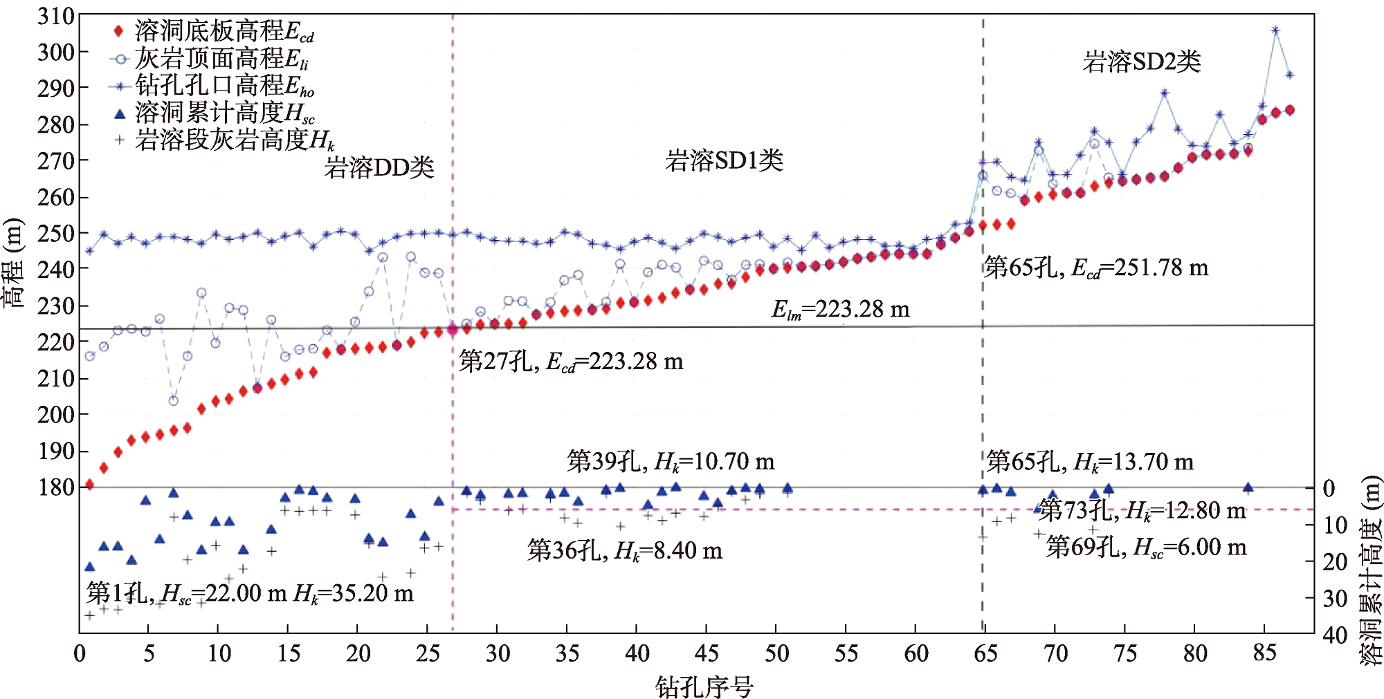
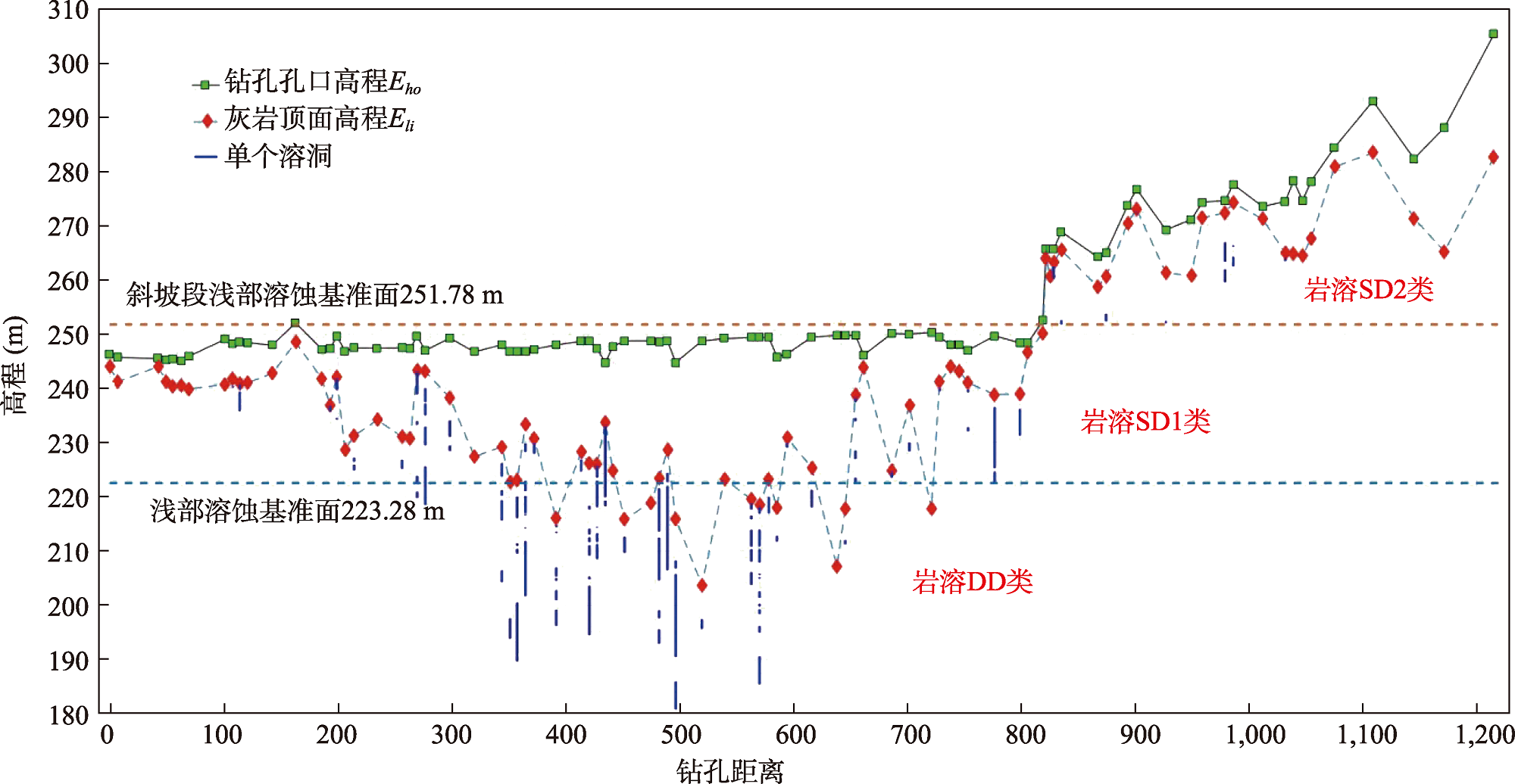
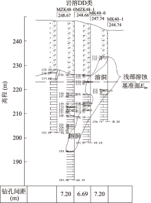
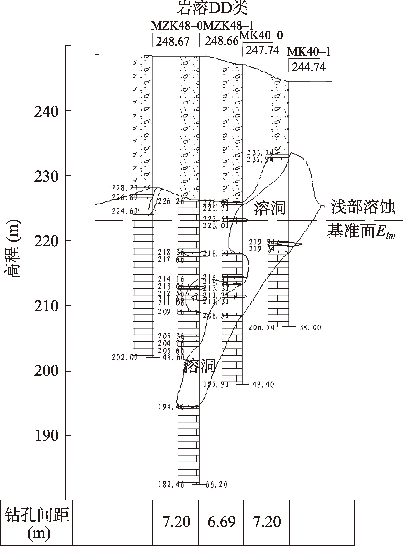
【背景】钻孔包含丰富的岩溶空间信息,但数据离散性大,难以直接用于刻画岩溶空间形态。【方法】以铜山源高架桥为例,全面收集各阶段钻孔数据,选择岩溶发育高程、高度、概率三类共6个指标,采用数理统计及指标散点图的单指标和多指标分析,探索岩溶形态多指标最优组合方法,获得岩溶形态统计规律及其分布特征。【结果】研究表明:(1)单一指标反映了岩溶形态不同方面的局部特征;(2)按溶洞底板高程从低到高顺序绘制的多指标散点图具有显著规律性,能确定浅部溶蚀基准面,进一步将钻孔岩溶划分为深部岩溶DD类和浅部岩溶SD类;(3)工程地质平面图中不同类型的岩溶具有明显分区特征,剖面图中具有不同的岩溶形态,工程地质条件差异大;(4)根据岩溶类型划分,使得勘察设计和施工更有针对性。【结论】岩溶多指标散点图方法,能有效解决工程建设中岩溶形态判断的困难,且能利用长期积累的大量钻孔数据,为定量分析区域岩溶发育情况提供基础。

关键词: 工程勘察, 岩溶形态, 浅部溶蚀基准面, 岩溶指标, 指标散点图

Abstract:

[Context] Boreholes contain abundant karst spatial information, but the data is highly discrete and difficult to describe directly the spatial morphology of karst. [Methods] In this paper, the Tongshanyuan viaduct is taken as an example. The drilling data of each stage is comprehensively collected; six indicators of karst development elevation, height, and probability are selected; and mathematical statistics and index scatter diagram are used to conduct single and multiple indicator analysis, to explore the optimal combination method of multiple indicators of karst morphology, and to obtain the statistical law and distribution characteristics of karst morphology. [Results] The study shows that: (1) a single index reflects the local characteristics of different aspects of karst morphology. (2) The multi-index scatter map drawn according to the order of karst cave floor elevation from low to high has significant regularity, which could determine the shallow karst base level. Through the relationship between the borehole karst cave floor elevation and the shallow karst base level, the borehole karst can be divided into deep karst DD class and shallow karst SD class. (3) Different types of karst in the engineering geological plan has obvious zoning characteristics, and different karst forms in the profile map has great differences in engineering geological conditions. (4) According to the classification of karst types, the survey, design, and construction are more targeted. [Conclusion] The karst multi-index scatter map method could effectively solve the difficulty of karst morphology judgment in engineering construction and could use a large number of long-term accumulated borehole data to provide a basis for quantitative analysis of regional karst development.

Key words: engineering survey, karst morphology, shallow corrosion base level, karst index, index scatter map