数据与计算发展前沿 ›› 2026, Vol. 8 ›› Issue (2): 82-97.
CSTR: 32002.14.jfdc.CN10-1649/TP.2026.02.007
doi: 10.11871/jfdc.issn.2096-742X.2026.02.007
• 专刊:冰冻圈大数据挖掘分析关键技术及应用 • 上一篇 下一篇
邱玉宝1,2,3,*( ),崔恒1,2,3,金泽楷1,2,3,李晓婷1,2,余淑文1,2,3
收稿日期:2025-10-13
出版日期:2026-04-20
发布日期:2026-04-23
通讯作者:
*邱玉宝(E-mail:作者简介:邱玉宝,中科院空天信息创新研究院研究员,可持续发展大数据国际研究中心数字环境研究室主任及学术建设委员会委员,从事微波遥感、冰雪及北极环境遥感、数字环境与可持续发展等研究工作。承担多项科技部国家重点研发计划项目(国际合作)、国家科技重大专项(2030重大科技专项 新一代人工智能)课题、中国科学院A类先导项目子课题和国家自然科学基金等国家和省部级项目,是地球观测组织(GEO)寒区监测计划的共同领导及联络人,担任“数字丝路”国际科学计划秘书长,获得省部级奖项2项,获得发明专利10余项,发表论文百余篇。基金资助:
QIU Yubao1,2,3,*(),CUI Heng1,2,3,JIN Zekai1,2,3,LI Xiaoting1,2,YU Shuwen1,2,3
Received:2025-10-13
Online:2026-04-20
Published:2026-04-23
摘要:
【背景】 气候变暖致使北极海冰持续减少,为全球交通和国际性贸易提供了新通道,北极航行已从探索阶段进入了发展期。在北冰洋少冰季、融冰或结冰期,航道环境信息的及时获取是安全航行的关键。【目的】 论文旨在基于空天数据、人工智能预报技术和综合性通航指数,发展北极航道环境信息获取、服务及数字化应用能力,构建应对北极航行安全和北极环境治理的航道环境数字化服务系统。【方法】 论文围绕当前空天数据的可获取性,遴选形成了影响北极航道的环境关键变量;以传统的可通航性指数为基础,引入降水、气温、水汽、海表温度、浪高等环境因子,构建了综合性通航评估模型;研制了基于空天数据的航道环境信息服务系统,在北极航行应急响应、年度计划和中长期规划等方面提供分层次的支撑服务;系统在我国北极探索性航行和北极极端环境探险性航行服务支撑中取得了实际效果。【结论】 该系统综合北极航道环境关键变量、多源空间数据、海冰预报技术、通航性评估模型,构建了航行分层服务策略,为北极航道环境信息服务、北极航行安全及环境治理提供了重要的数字化工具。
邱玉宝, 崔恒, 金泽楷, 李晓婷, 余淑文. 北极航道环境数字化服务及应用研究[J]. 数据与计算发展前沿, 2026, 8(2): 82-97.
QIU Yubao, CUI Heng, JIN Zekai, LI Xiaoting, YU Shuwen. Research on Digital Environment Services for Arctic Sea Route[J]. Frontiers of Data and Computing, 2026, 8(2): 82-97, https://cstr.cn/32002.14.jfdc.CN10-1649/TP.2026.02.007.
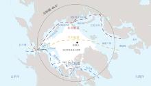
图1
北极航线东北航道、西北航道、中央航道及最小海冰范围(2025)"
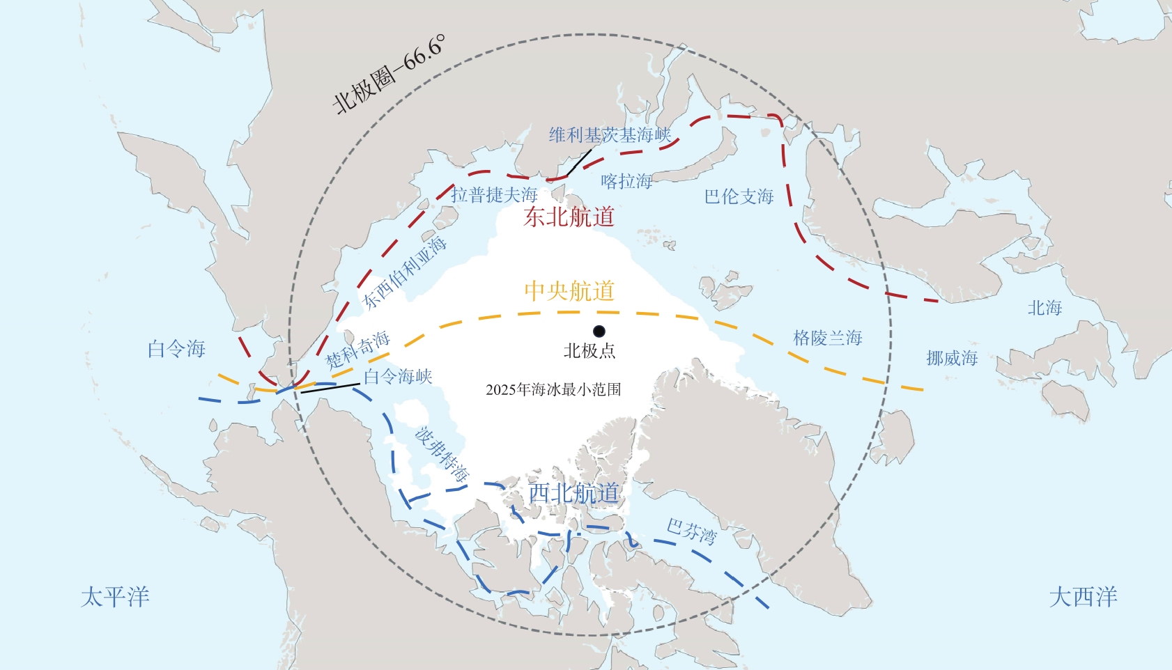
表1
北极航道环境通航性关键变量分类及应用"
| 类别 | 关键变量 | 观测指标 | 主要作用 | 应用场景 |
|---|---|---|---|---|
| 冰况类 | 海冰类型 | 多年冰/一年冰 | 冰情/船冰级需求 | 航线规划 |
| 海冰厚度 | 最大/平均厚度 | 影响航行 | 航行安全 | |
| 海冰密集度 | 覆盖率 | 影响航行 | 航行安全 | |
| 海冰漂移 | 速度/方向 | 流冰运动 | 航行安全 | |
| 浮冰/冰山 | 位置/范围 | 航道影响 | 航道安全 | |
| 海况类 | 洋流 | 流速/流向 | 影响冰漂移/分布 | 航线安全 |
| 温度 | 海表温度 | 影响结冰与消融 | 航行安全 | |
| 风场 | 海表风速/风向 | 影响冰漂移/气象条件 | 航行安全 | |
| 海浪 | 浪高/方向 | 影响冰漂移 | 航行安全 | |
| 气象水文类 | 降水 | 雪深/雨量 | 气象条件 | 模型输入 |
| 海雾 | 能见度(<1 km) | 天气条件 | 航行安全 | |
| 水汽 | 水汽含量 | 水汽强度 | 模型输入 | |
| 风场 | 风速/风向 | 气象条件 | 模型输入 | |
| 预报输入变量类 | 积雪 | 积雪覆盖度 | 影响陆-海相互作用 | 模型输入 |
| 云参数 | 云量/云底高度 | 影响辐射/气预测 | 模型输入 |
图2
SIFNet海冰预报模型结构图[72]"
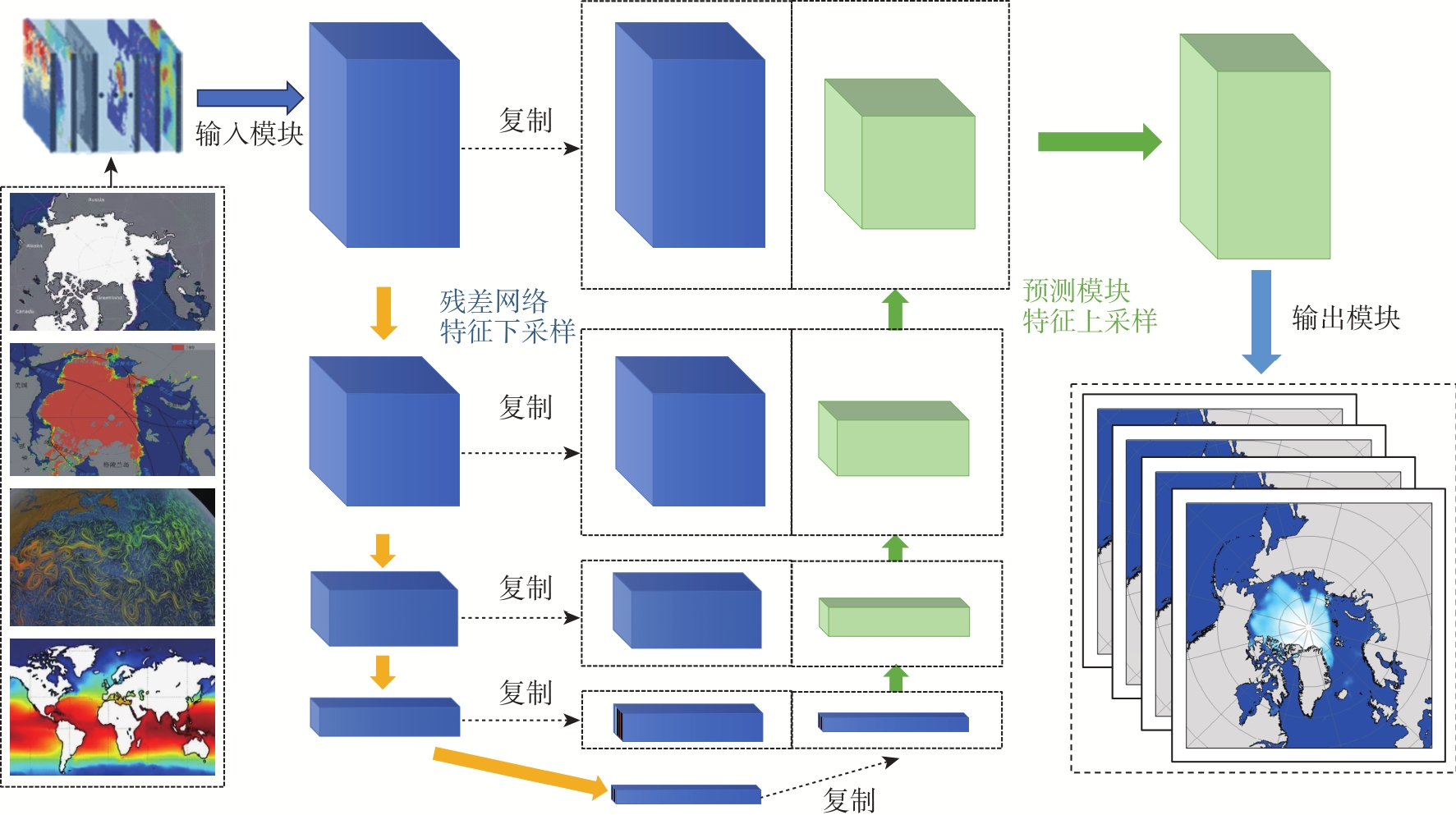
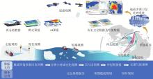
图3
北极航道环境信息服务概略图"
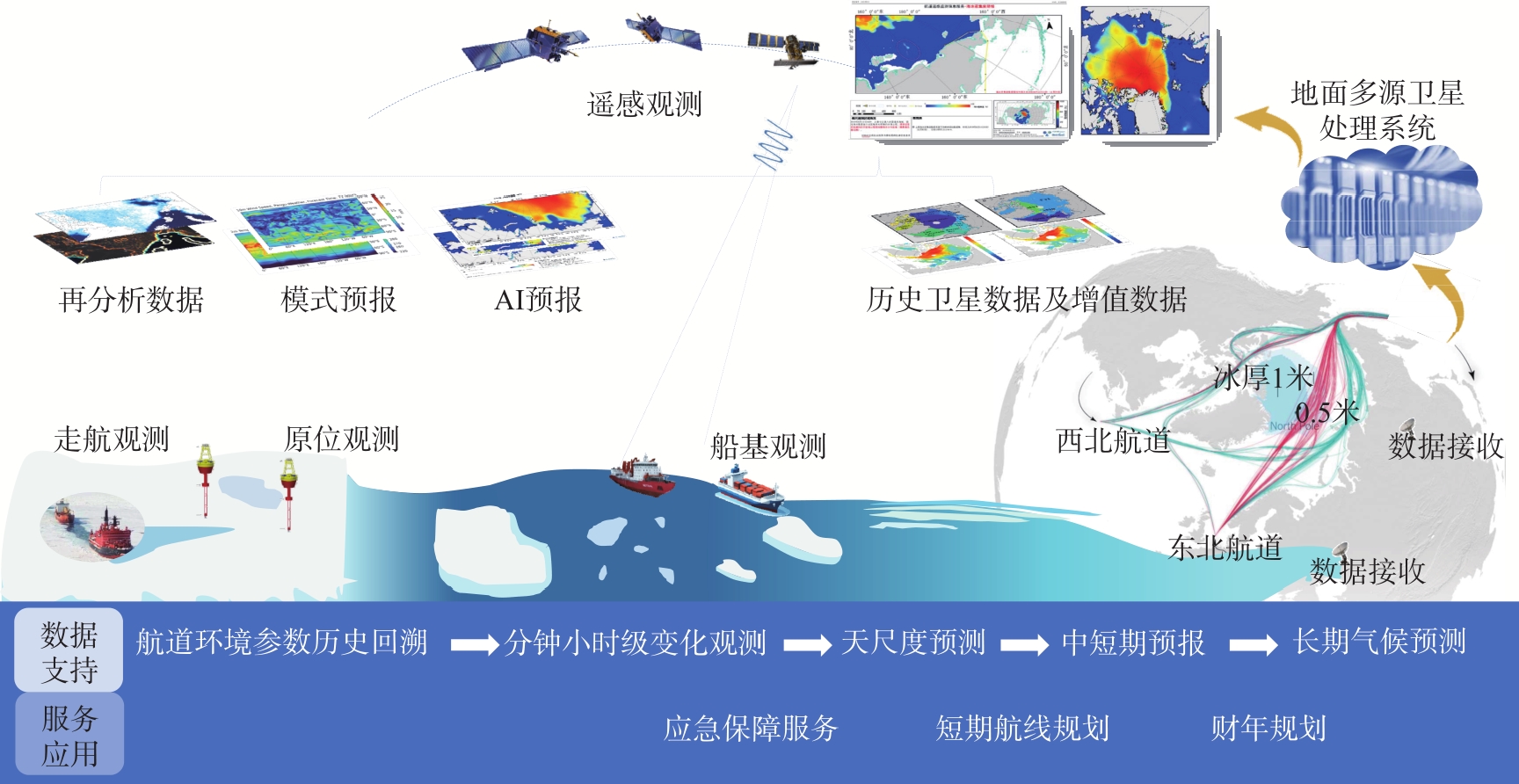
图4
航道环境信息服务系统数据组织模式"
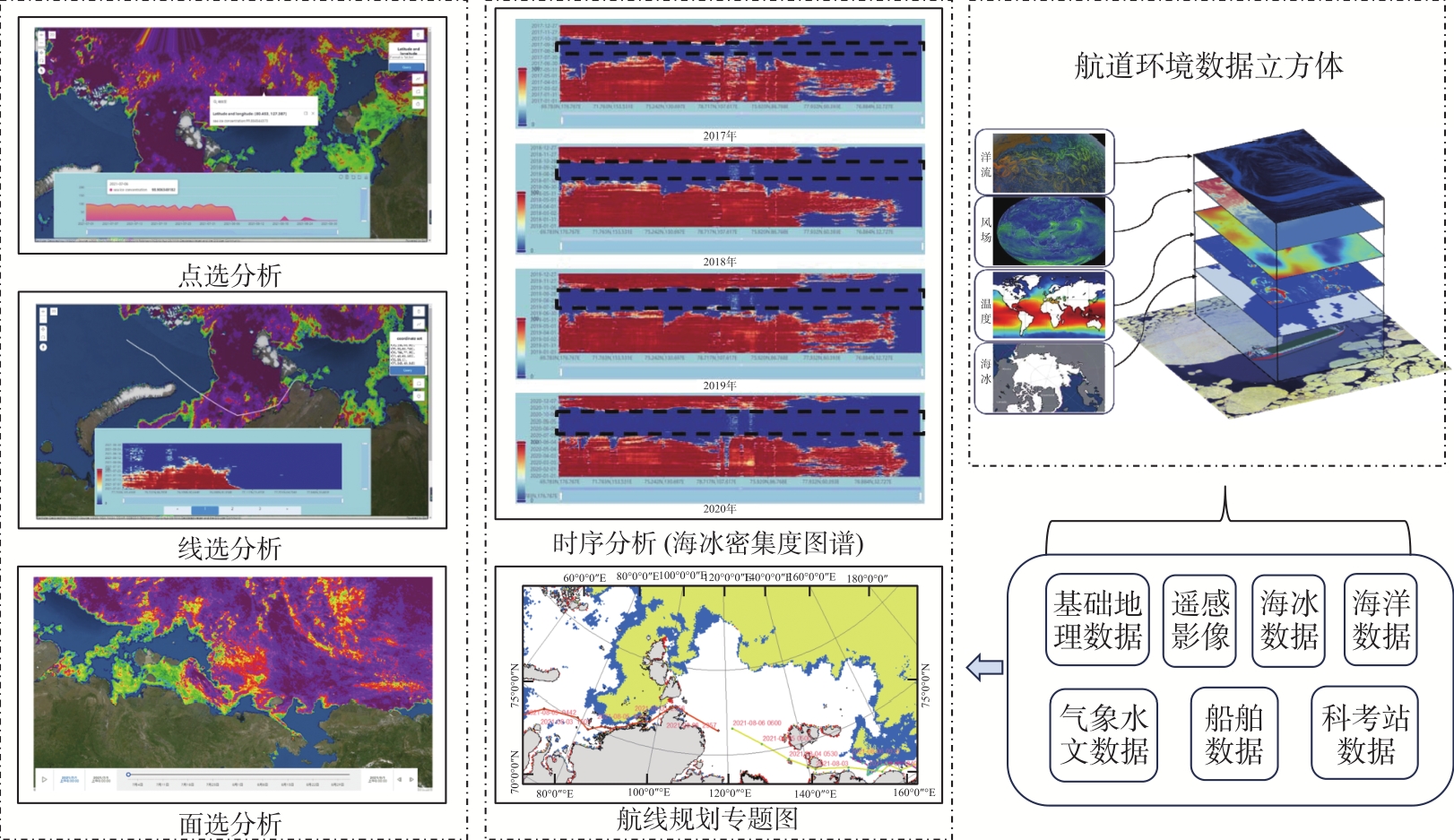
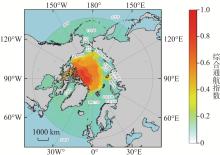
图5
在翟墨号提供风险预警决策过程总,所采用的综合通航指数分布图(2021年8月1日) 注:蓝绿色为低风险区域,黄色为中风险区域,红色为高风险区域。"
图6
数字化北极航道环境信息服务系统技术架构"
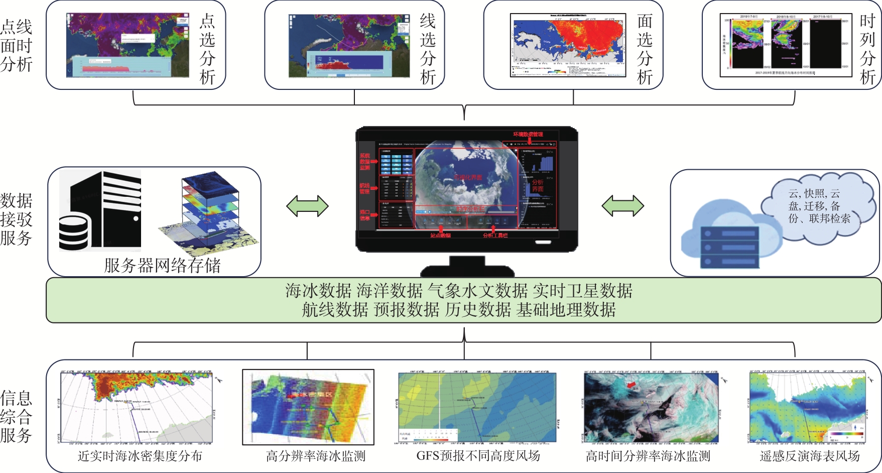
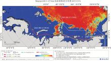
图7
航道环境信息系统数据可视化及2021年服务示例"
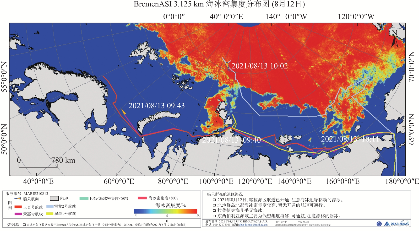

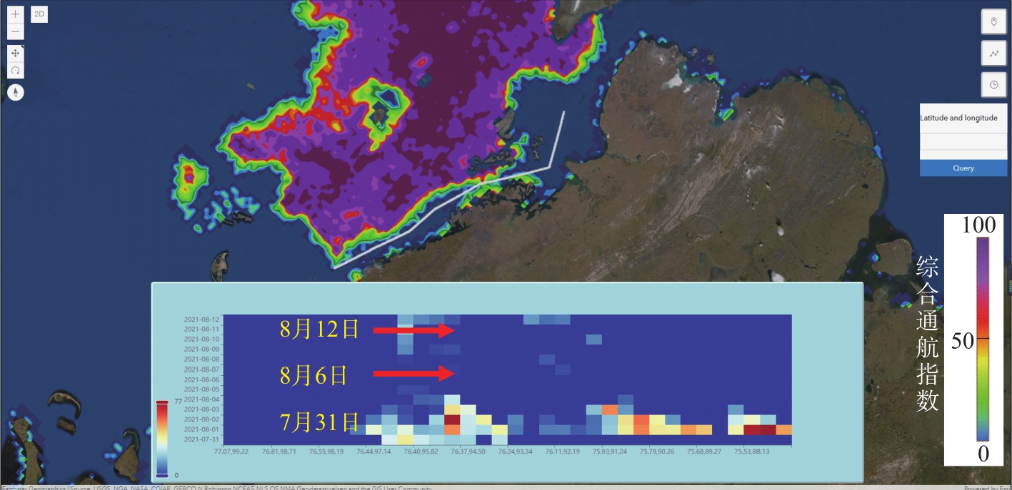
图8
系统为“翟墨号”环北极航行提供的海冰密集度时间图谱(2021年8月)"
| [1] | ZHAO P, LI Y, ZHANG Y. Ships are projected to navigate whole year-round along the North Sea route by 2100[J]. Communications Earth & Environment, 2024, 5: 407. |
| [2] | RANTANEN M, KARPECHKO A Y, LIPPONEN A, et al. The Arctic has warmed nearly four times faster than the globe since 1979[J]. Communications Earth & Environment, 2022, 3(1): 168. |
| [3] | BERKMAN P A, BAESEMAN J, SHIBATA A. Arctic science diplomacy maintains Russia co-operation[J]. Nature, 2022, 604(7907): 625. |
| [4] | ROBERTS K. Geopolitics and diplomacy in Canadian Arctic relations[C]// Brown D, Smith A, eds. Political Turmoil in a Tumultuous World: Canada Among Nations 2020. Cham: Springer International Publishing, 2021: 125-146. |
| [5] |
YANG M, QIU Y, HUANG L, CHENG M, et al. Changes in sea surface temperature and sea ice concentration in the Arctic Ocean over the past two decades[J]. Remote Sensing, 2023, 15(4): 1095.
doi: 10.3390/rs15041095 |
| [6] | YANG Z J, ZHANG L X. Literature review on the safety of Arctic shipping routes[J]. Marine Information, 2016, 227: 56-62. |
| [7] |
BALMAT J F, LAFONT F, MAIFRET R, et al. Maritime risk assessment (MARISA), a fuzzy approach to define an individual ship risk factor[J]. Ocean Engineering, 2009, 36: 1278-1286.
doi: 10.1016/j.oceaneng.2009.07.003 |
| [8] | DING F, LIU J, ZHAO W, et al. Risk level grading for ship pilotage based on weather conditions[J]. Navigation of China, 2019, 42: 71-74. |
| [9] | FU S S, ZHAO X F, ZHANG T, et al. Identification of environmental risk influencing factors for ship operations in Arctic waters[J]. Journal of Harbin Engineering University, 2017, 38: 1682-1688. |
| [10] |
HUANG J, LI C, WANG Y, et al. The evolution of navigation performance of Northeast Passage under the scenario of Arctic sea ice melting[J]. Acta Geographica Sinica, 2021, 76: 1051-1064.
doi: 10.11821/dlxb202105001 |
| [11] | HAN H. Study on the spatial and temporal distribution of sea ice and the physical, mechanical properties of sea ice in polar routes[D]. Dalian: Dalian University of Technology, 2016. |
| [12] |
ZHAO P, LI Y, ZHANG C, et al. Arctic sea route access reshapes global shipping carbon emissions[J]. Nature Communications, 2025, 16: 8431.
doi: 10.1038/s41467-025-64437-4 |
| [13] | QIU Y, GABARRÓ C, GEOCRI G. Statement on the GEO cold region initiative (GEOCRI)[C]. Arctic Observing Summit 2016. Fairbanks, Alaska, 2016. https://earthobservations.org/documents/meetings/201603_arctic_summit/201603_arctic_summit_geocri_statement.pdf |
| [14] |
DU J, WATTS J D, JIANG L, et al. Remote sensing of environmental changes in cold regions: Methods, achievements and challenges[J]. Remote Sensing, 2019, 11(16): 1952.
doi: 10.3390/rs11161952 |
| [15] |
CHEN J, ZHOU L, DING S, et al. Numerical simulation of moored ships in level ice considering dynamic behavior of mooring cable[J]. Marine Structures, 2025, 99: 103716.
doi: 10.1016/j.marstruc.2024.103716 |
| [16] |
HUANG J, DIAO F, DING S, et al. A study on the ice resistance characteristics of ships in rafted ice based on the circumferential crack method[J]. Water, 2024, 16(6): 854.
doi: 10.3390/w16060854 |
| [17] |
CAI J, DING S, ZHANG Q, et al. Broken ice circumferential crack estimation via image techniques[J]. Ocean Engineering, 2022, 259: 111735.
doi: 10.1016/j.oceaneng.2022.111735 |
| [18] | FEDOROV V P, ZHURAVEL V P, GRINYAEV S N, et al. The Northern Sea Route: problems and prospects of development of transport route in the Arctic[C]// IOP Conference Series:Earth and Environmental Science. IOP Publishing, 2020, 434(1): 012007. |
| [19] |
CHEN J L, LI M, ZHAO Y, et al. Variation of sea ice and perspectives of the Northwest Passage in the Arctic Ocean[J]. Advances in Climate Change Research, 2021, 12: 447-455.
doi: 10.1016/j.accre.2021.02.002 |
| [20] |
CHEN J, LI C, LIU J, et al. Changes in sea ice and future accessibility along the Arctic Northeast Passage[J]. Global and Planetary Change, 2020, 195: 103319.
doi: 10.1016/j.gloplacha.2020.103319 |
| [21] | HUMPERT M, RASPOTNIK A. The future of Arctic shipping along the transpolar sea route[J]. Arctic Yearbook, 2012, 2012(1): 281-307. |
| [22] |
CHEN J, LI C, LIU J, et al. Perspectives on future sea ice and navigability in the Arctic[J]. Cryosphere, 2021, 15: 5473-5482.
doi: 10.5194/tc-15-5473-2021 |
| [23] |
KWOK R. Arctic sea ice thickness, volume, and multiyear ice coverage: losses and coupled variability (1958-2018)[J]. Environmental Research Letters, 2018, 13: 105005.
doi: 10.1088/1748-9326/aae3ec |
| [24] |
LIU J, ZHANG Z, WANG M, et al. Reducing spread in climate model projections of a September ice-free Arctic[J]. Proceedings of the National Academy of Sciences, 2013, 110: 12571-12576.
doi: 10.1073/pnas.1219716110 |
| [25] |
STROEVE J, NOTZ D. Changing state of Arctic sea ice across all seasons[J]. Environmental Research Letters, 2018, 13: 103001.
doi: 10.1088/1748-9326/aade56 |
| [26] | 海事服务网. 2019北极航行手记丨船长,您辛苦了![EB/OL]. (2019-08-10)[2025-10-02]. https://www.zgsyb.com/news.html?aid=511043. |
| [27] | 陆海鸣. 2021年商船北极东北航道航行回顾及思考[EB/OL]. (2022-01-12)[2025-10-02]. https://www.xindemarinenews.com/topic/hangyunanquan/2022/0112/35544.html. |
| [28] | 任鹏军. 爆炸+冰区俄罗斯港口UST LUGA 注意事项[EB/OL]. (2024-01-25)[2025-10-02]. https://www.xindemarinenews.com/topic/hangyunanquan/2024/0125/52661.html. |
| [29] | IMO. International Code for Ships Operating in Polar Waters (Polar Code)[S]. International Maritime Organization, 2014. |
| [30] | IACS. Requirements concerning Polar Class[S]. International Association of Classification Societies, 2007. |
| [31] | Transport Canada. Arctic Ice Regime Shipping System (AIRSS) Standards[S]. Ottawa, 1996. |
| [32] | IMO. Guidelines for the application of the POLARIS (Polar Operational Limit Assessment Risk Indexing System)[S]. International Maritime Organization, 2016. |
| [33] | MU L, YANG Q, LOSCH M, et al. Improving Arctic sea ice thickness forecasts by assimilating CryoSat-2 and SMOS sea ice thickness data[J]. The Cryosphere, 2018, 12: 3731-3747. |
| [34] |
LEA D J, MIROUZE I, MARTIN M J, et al. Assessing a new coupled data assimilation system based on the Met Office coupled atmosphere-land-ocean-sea ice model[J]. Monthly Weather Review, 2015, 143(11): 4678-4694.
doi: 10.1175/MWR-D-15-0174.1 |
| [35] | POSEY P G, METZGER E J, WALLCRAFT A J, et al. Implementing the Arctic Cap Nowcast/Forecast System (ACNFS)[J]. Journal of Atmospheric and Oceanic Technology, 2015, 32(9): 1573-1588. |
| [36] |
YANG Q, LOSA S N, LOSCH M, et al. Assimilating SMOS sea ice thickness into a coupled ice-ocean model using a local SEIK filter[J]. Journal of Geophysical Research: Oceans, 2014, 119: 6680-6692.
doi: 10.1002/jgrc.v119.10 |
| [37] |
YANG Q, MU L, WU X, et al. Improving Arctic sea ice seasonal outlook by ensemble prediction using an ice-ocean model[J]. Atmospheric Research, 2019, 227: 14-23.
doi: 10.1016/j.atmosres.2019.04.021 |
| [38] | BESZCZYNSKA-MöLLER A, SANDVEN S, SAGEN H. INTAROS: Development of an integrated Arctic observation system under Horizon 2020[C]// EGU General Assembly Conference Abstracts, 2017. |
| [39] | GROSFELD L, LENZ J. Arctic PASSION Sharing Circle[Z]. 2024. |
| [40] |
SHUPE M D, REX M, BLOMQUIST B, et al. Overview of the MOSAiC expedition: Atmosphere, sea ice, ocean, and ecosystem observations[J]. Elementa: Science of the Anthropocene, 2022, 10(1): 000046.
doi: 10.1525/elementa.2021.000046 |
| [41] | LI Y, ZHANG C, QIU Y, et al. An explainable deep learning model for daily sea ice concentration forecast[J]. IEEE Transactions on Geoscience and Remote Sensing, 2024, 62: 1-17. |
| [42] | WU A, CHE T, CHEN J, et al. RouteView 2.0: A real-time operational planning system for vessels on the Arctic Northeast Passage[J]. Environmental Modelling & Software, 2025. |
| [43] |
HUANG L, QIU Y, LI Y, et al. DynIceData: a gridded ice-water classification dataset at short-time intervals based on observations from multiple satellites over the marginal ice zone[J]. Big Earth Data, 2024, 8(2): 249-273.
doi: 10.1080/20964471.2023.2230714 |
| [44] | SIMIONATO C. International Association of the Physical Sciences of the Oceans[J]. Geosciences: The Future, 2003: 29. |
| [45] | AMAP. Arctic Marine Environment Assessment Report[R]. Oslo: Arctic Monitoring and Assessment Programme (AMAP), 2021. |
| [46] | LI X. Research on deep learning-driven sea ice prediction for Arctic sea routes[C]// 2025 6th International Conference on Computer Vision, Image and Deep Learning (CVIDL). IEEE, 2025: 794-798. |
| [47] | WMO. WMO Statement on the State of the Global Climate 2020[R]. Geneva: World Meteorological Organization, 2020. |
| [48] | CHENG L, VON SCHUCKMANN K, ABRAHAM J P, et al. Past and future ocean warming[J]. Nature Reviews Earth & Environment, 2022, 3(11): 776-794. |
| [49] | 中国交通运输部海事局. 北极航行指南(Polar Code)[S]. 北京: 中国交通运输部海事局, 2014. MSC.385(94), MSC.386(94), MEPC.264(68). |
| [50] | Group on Earth Observations (GEO). GEOSS: An Information Service for Cold Regions-Conclusion and Recommendations from GEO Cold Regions Side Event[R]. Geneva, Switzerland, 2014. |
| [51] | 邱玉宝, 余淑文, 李晓婷, 等. 短时间间隔高空间分辨率北极海冰冰水分类数据集[DB/OL]. 国家冰川冻土沙漠科学数据中心(http://www.ncdc.ac.cn), 2025. https://cstr.cn/CSTR:11738.11.NCDC.NIEER.DB6894.2025. |
| [52] | REYERS B, STAFFORD-SMITH M, ERB K H, et al. Essential variables help to focus sustainable development goals monitoring[J]. Current Opinion in Environmental Sustainability, 2017, 26: 97-105. |
| [53] | IMO. Guidelines for Ships Operating in Polar Waters: Arctic Navigation Environment Information Service Guide[R]. London: International Maritime Organization, 2019. |
| [54] |
CHEN J, ZHANG X, XU L, et al. How environmental data enables intelligent navigation: Factors assessment of affecting the navigation in the Northeast Arctic Route[J]. Regional Studies in Marine Science, 2024, 79: 103861.
doi: 10.1016/j.rsma.2024.103861 |
| [55] |
LIU Y, MA X, QIAO W, et al. On the determination and rank for the environmental risk aspects for ship navigating in the Arctic based on big Earth data[J]. Risk Analysis, 2023, 43(11): 2186-2210.
doi: 10.1111/risa.v43.11 |
| [56] | STODDARD M A, SMITH D, LIU H, et al. Making sense of Arctic maritime traffic using the Polar Operational Limits Assessment Risk Indexing System (POLARIS)[C]// IOP Conference Series: Earth and Environmental Science. IOP Publishing, 2016. |
| [57] | 国家重点研发计划“政府间国际科技创新合作”重点专项. 北极环境多要素空间观测与信息服务研究(项目编号:2017YFE0111700)[R]. 北京: 中国科技部, 2018- 2021. |
| [58] | 国家重点研发计划“政府间国际科技创新合作”重点专项. 数字化北极航运:遥感信息快速监测及短期预报研究(项目编号:2019YFE0105700)[R]. 北京: 中国科技部, 2020- 2023. |
| [59] |
SHYU W H, DING J F. Key factors influencing the building of Arctic shipping routes[J]. The Journal of Navigation, 2016, 69(6): 1261-1277.
doi: 10.1017/S0373463316000254 |
| [60] |
WU A, CHE T, LI X, et al. RouteView: an intelligent route planning system for ships sailing through Arctic ice zones based on big Earth data[J]. International Journal of Digital Earth, 2022, 15(1): 1588-1613.
doi: 10.1080/17538947.2022.2126016 |
| [61] |
CARLSON D, ODA T. Data publication-ESSD goals, practices and recommendations[J]. Earth System Science Data, 2018, 10(4): 2275-2278.
doi: 10.5194/essd-10-2275-2018 |
| [62] |
GUO H, LIU Z, JIANG H, et al. Big Earth Data: a new challenge and opportunity for Digital Earth’s development[J]. International Journal of Digital Earth, 2017, 10(1): 1-12.
doi: 10.1080/17538947.2016.1264490 |
| [63] | HUNKE E C, LIPSCOMB W H, TURNER A K, et al. CICE: the Los Alamos Sea Ice Model documentation and software, version 5.1[R]. Los Alamos National Laboratory, 2015. |
| [64] |
SAKOV P, COUNILLON F, BERTINO L, et al. TOPAZ4: An ocean-sea ice data assimilation system for the North Atlantic and Arctic[J]. Ocean Science, 2012, 8(4): 633-656.
doi: 10.5194/os-8-633-2012 |
| [65] |
POSEY P G, METZGER E J, WALLCRAFT A J, et al. Improving Arctic sea ice edge forecasts by assimilating high horizontal resolution sea ice concentration data into the US Navy’s ice forecast systems[J]. The Cryosphere, 2015, 9(5): 1735-1745.
doi: 10.5194/tc-9-1735-2015 |
| [66] |
JOHNSON S J, STOCKDALE T N, FERRANTI L, et al. SEAS5: the new ECMWF seasonal forecast system[J]. Geoscientific Model Development, 2019, 12(3): 1087-1117.
doi: 10.5194/gmd-12-1087-2019 |
| [67] |
MACLACHLAN C, ARRIBAS A, PETERSON K A, et al. Global seasonal forecast system version 5 (GloSea5): a high-resolution seasonal forecast system[J]. Quarterly Journal of the Royal Meteorological Society, 2015, 141(689): 1072-1084.
doi: 10.1002/qj.2015.141.issue-689 |
| [68] |
XIE J, COUNILLON F, BERTINO L, et al. Benefits of assimilating thin sea ice thickness from SMOS into the TOPAZ system[J]. The Cryosphere, 2016, 10(6): 2745-2761.
doi: 10.5194/tc-10-2745-2016 |
| [69] | YAN H, CHEN D, JIANG G, et al. DGraFormer: dynamic graph learning guided multi-scale transformer for multivariate time series forecasting[J]. Proceedings of IJCAI, 2025: 3516-3524. |
| [70] |
ANDERSSON T R, HOSKING J S, PéREZ-ORTIZ M, et al. Seasonal Arctic sea ice forecasting with probabilistic deep learning[J]. Nature Communications, 2021, 12(1): 5124.
doi: 10.1038/s41467-021-25257-4 pmid: 34446701 |
| [71] | REN Y, LI X, WANG Y. SICNet season V1.0: a transformer-based deep learning model for seasonal Arctic sea ice prediction by integrating sea ice thickness data[J]. Geoscientific Model Development, 2024. |
| [72] | LI Y, QIU Y, JIA G, et al. An explainable deep learning model for daily sea ice concentration forecast[J]. IEEE Transactions on Geoscience and Remote Sensing, 2024, 62: 4301217. |
| [73] | 中国科学院空天信息创新研究院. 2024SR1205630. 数字北极航道环境信息服务系统 V1.0[CP/CD]. 2024 (2024-08-19) [2025-10-04]. 国家版权局. |
| [74] |
HUANG Y, KLEINDESSNER M, MUNISHKIN A, et al. Benchmarking of data-driven causality discovery approaches in the interactions of Arctic sea ice and atmosphere[J]. Frontiers in Big Data, 2021, 4: 642182.
doi: 10.3389/fdata.2021.642182 |
| [75] |
GUO D, JI S, YAO Y, et al. A decentralized path planning model based on deep reinforcement learning[J]. Computers and Electrical Engineering, 2024, 117: 109276.
doi: 10.1016/j.compeleceng.2024.109276 |
| [76] | CORBETT J J, LACK D A, WINEBRAKE J J, et al. Arctic shipping emissions inventories and future scenarios[J]. Atmospheric Chemistry and Physics, 2010, 10: 9689-9704. |
| No related articles found! |
| 阅读次数 | ||||||
|
全文 |
|
|||||
|
摘要 |
|
|||||