| [1] |
王文秀. 红外遥感图像舰船目标在线检测关键技术研究[D]. 上海: 中国科学院大学(中国科学院上海技术物理研究所), 2019: 1-3.
|
| [2] |
张兰丹. 基于张量恢复的红外弱小目标检测方法研究[D]. 成都: 电子科技大学, 2020: 1-5.
|
| [3] |
XIA, G S, BAI X, DING J, et al. DOTA: A large-scale dataset for object detection in aerial images[C]// Proceedings of the IEEE Conference on Computer Vision and Pattern Recognition, San Francisco, CA, USA: IEEE, 2018: 3974-3983.
|
| [4] |
LIU Z, WANG H, WENG L, et al. Ship rotated bounding box space for ship extraction from high-resolution optical satellite images with complex backgrounds[J]. IEEE Geoscience and Remote Sensing Letters. 2016, 13(8), 1074-1078.
doi: 10.1109/LGRS.2016.2565705
|
| [5] |
CHENG G, ZHOU P, HAN J. Learning rotation-invariant convolutional neural networks for object detection in VHR optical remote sensing images[J]. IEEE Transactions on Geoscience and Remote Sensing. 2016, 54(12): 7405-7415.
doi: 10.1109/TGRS.2016.2601622
|
| [6] |
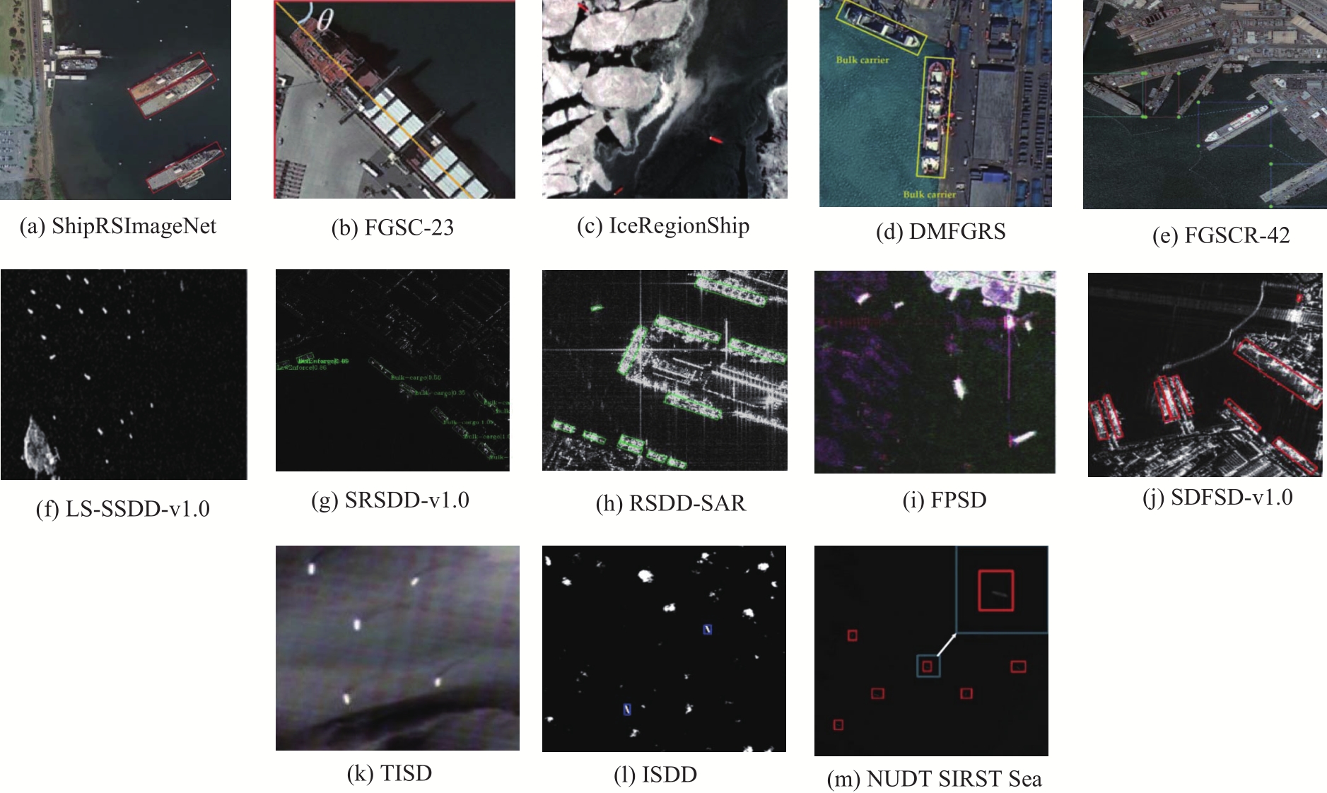
ZHNAG Z, ZHANG L, WANG Y, et al. ShipRSImageNet: A Large-Scale Fine-Grained Dataset for Ship Detection in High-Resolution Optical Remote Sensing Images[J]. Applied Earth Observations and Remote Sensing. 2021, 14: 8458-8471.
|
| [7] |
LAM D, KUZMA R, MCGEE K, et al. xView: Objects in Context in Overhead Imagery[J]. 2018.DOI:10.48550/arXiv.1802.07856.
|
| [8] |
CHEN K, WU M, LIU J, et al. FGSD: A Dataset for Fine-Grained Ship Detection in High Resolution Satellite Images[J]. arXiv preprint arXiv:2003.06887. 2020: 1-8.
|
| [9] |
姚力波, 张筱晗, 吕亚飞, 等. FGSC-23: 面向深度学习精细识别的高分辨率光学遥感图像舰船目标数据集[J]. 中国图象图形学报, 2021, 26(10): 2337-2345.
|
| [10] |
DI Y H, JIANG Z G, ZHANG H P. A public dataset for fine-grained ship classification in optical remote sensing images[J]. Remote Sensing, 2021, 13(4): 747.
doi: 10.3390/rs13040747
|
| [11] |
WANG P, LIU B, LI Y, et al. IceRegionShip: Optical Remote Sensing Dataset for Ship Detection in Ice-Infested Waters[J]. Applied Earth Observations and Remote Sensing, 2024, 17: 1007-1020.
|
| [12] |
SONG S, ZHANG R, HU M, et al. Fine-Grained Ship Recognition Based on Visible and Near-Infrared Multimodal Remote Sensing Images: Dataset, Methodology and Evaluation[J]. Computers, Materials & Continua. 2024, 79(3): 5244-5271.
|
| [13] |
WANG W, DENG Y, LIU D, et al. Forthcoming Spaceborne SAR Development[J]. Journal of Radars, 2020, 9(1): 1-33.
|
| [14] |
LI J, QU C, SHAO J. Ship detection in SAR images based on an improved Faster R-CNN[C]// Proceedings of the 2017 SAR in Big Data Era:Models, Methods and Applications (BIGSARDATA). Beijing, China: IEEE, 2017: 1-6.
|
| [15] |
WANG Y, WANG C, ZHANG H, et al. A SAR dataset of ship detection for deep learning under complex backgrounds[J]. Remote Sensing, 2019, 11(7): 765.
doi: 10.3390/rs11070765
|
| [16] |
ZHANG T, ZHANG X, KE X, et al. LS-SSDD-v1.0: A deep learning dataset dedicated to small ship detection from large-scale Sentinel-1 SAR images[J]. Remote Sensing, 2020, 12(18): 2997.
doi: 10.3390/rs12182997
|
| [17] |
LEI S, LU D, QIU X, et al. SRSDDv1.0: A high-resolution SAR rotation ship detection dataset[J]. Remote Sensing, 2021, 13(24): 5104.
doi: 10.3390/rs13245104
|
| [18] |
徐从安, 苏航, 李健伟, 等. RSDD-SAR:SAR舰船斜框检测数据集[J]. 雷达学报, 2022, 11(4): 581-599.
|
| [19] |
YANG Z, ZHANG P, WANG N, et al. A Lightweight Theory-Driven Network and Its Validation on Public Fully Polarized Ship Detection Dataset[J]. Applied Earth Observations and Remote Sensin, 2024, 17:3755
|
| [20] |
CAI P, LIU B, WANG P, et al. SDFSD-v1.0: A Sub-Meter SAR Dataset for Fine-Grained Ship Detection[J]. Remote Sensing, 2024, 16(21): 3952.
doi: 10.3390/rs16213952
|
| [21] |
WANG N, LI B, WEI X, et al. Ship detection in spaceborne infrared image based on lightweight CNN and multisource feature cascade decision[J]. IEEE Transactions on Geoscience and Remote Sensing, 2021, 59(5): 4324-4339.
doi: 10.1109/TGRS.2020.3008993
|
| [22] |
LI L, YU J, CHEN F. TISD: A Three Bands Thermal Infrared Dataset for All Day Ship Detection in Spaceborne Imagery[J]. Remote Sens, 2022, 14(21): 5297.
doi: 10.3390/rs14215297
|
| [23] |
HAN Y, LIAO J, LU T, et al. KCPNet: Knowledge-driven context perception networks for ship detection in infrared imagery[J], IEEE Transactions on Geoscience and Remote Sensing, 2023, 61.
|
| [24] |
WU T H, LI B Y, LUO Y H, et al, MTU-Net: Multilevel TransUnet for space-based infrared tiny ship detection[J], IEEE Transactions on Geoscience and Remote Sensing, 2023, 61.
|
 ),ZHANG Yiming,LIU Yuanyuan,HUANG Shan