Frontiers of Data and Computing ›› 2022, Vol. 4 ›› Issue (1): 113-125.

doi: 10.11871/jfdc.issn.2096-742X.2022.01.009

• Special Issue: Union of National Scientific Data Center • Previous Articles    
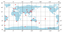
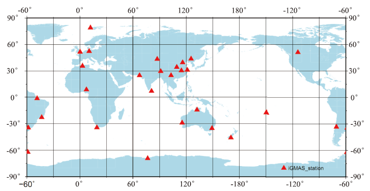
Research and Application of iGMAS Data Collection and Service

ZHANG Zhe1,2,3,*(),YANG Haiyan1,2,3(),WANG Haixue1,2,3(),WANG Ge1,2,3(),HE Zhanke1,2,3(),XU Yongliang1,2,3(),SUN Baoqi1,2,3(),YANG Xuhai1,2,3()   

  1. 1. National Time Service Center, Chinese Academy of Sciences, Xi’an, Shaanxi 710600, China
    2. Key Laboratory of Precise Positioning and Timing Technology, Chinese Academy of Sciences, Xi’an, Shaanxi 710600, China
    3. University of Chinese Academy of Sciences, Beijing 100049, China
  • Received:2021-10-07 Online:2022-02-20 Published:2022-03-04
  • Contact: ZHANG Zhe E-mail:zhangzhe@ntsc.ac.cn;yanghy@ntsc.ac.cn;wanghaixue@ntsc.ac.cn;wangge@ntsc.ac.cn;hzk@ntsc.ac.cn;xuyl@ntsc.ac.cn;sunbaoqi@ntsc.ac.cn;yyang@ntsc.ac.cn

Abstract:

[Objective] The international GNSS Monitoring and Assessment System (iGMAS) monitors and evaluates the operation status and performance of the world’s four major satellite navigation systems through the deployment of a global tracking station network. It is composed of a global tracking station network, data centers, etc. [Methods] The global tracking station network is responsible for the collection and preprocessing of the observation data from the navigation satellites, such as code pseudo range, carrier phase, and Doppler data, and transmits the data to the data center. The data center collects the standard format observation data of the tracking station network and performs quality inspections, classification, storage, and backup. At the same time, it receives precise products such as orbit, clock offset, atmosphere corrections processed by the analysis center and product service center. It provides standard format data and products through a variety of methods, such as FTP and WEB. [Results] The data and products have been applied in many fields such as GNSS monitoring and evaluation, precise time and frequency field, geodynamics, atmospheric science, precise surveying, and mapping.

Key words: Beidou, GNSS, iGMAS, data collection, data service