Frontiers of Data and Computing ›› 2025, Vol. 7 ›› Issue (4): 54-66.
CSTR: 32002.14.jfdc.CN10-1649/TP.2025.04.005
doi: 10.11871/jfdc.issn.2096-742X.2025.04.005
• Special Issue: Artificially Intelligent Models and Tools for Space Science Big Data • Previous Articles Next Articles
LIU Changqing*( ),LYU Yingbo,LING Zongcheng
Received:2025-06-30
Online:2025-08-20
Published:2025-08-21
Contact:
LIU Changqing
E-mail:liucq@sdu.edu.cn
LIU Changqing, LYU Yingbo, LING Zongcheng. Software Development for Martian Mineral Identification and Distribution Mapping[J]. Frontiers of Data and Computing, 2025, 7(4): 54-66, https://cstr.cn/32002.14.jfdc.CN10-1649/TP.2025.04.005.
Table 1
Mineral types and spectral number in RELAB database"
| 矿物类型 | 矿物名称 | RELAB光谱编号 | |
|---|---|---|---|
| 火成矿物 | 辉石 | 低钙辉石 | C1PX17 |
| 高钙辉石 | C1PX18 | ||
| 橄榄石 | 镁橄榄石 | C1DD37 | |
| 铁橄榄石 | C1DD45 | ||
| 斜长石 | 斜长石 | C2LR210 | |
| 硫酸盐 | 钙硫酸盐 | 石膏 | C2PG03 |
| 硬石膏 | CAEC02 | ||
| 铁硫酸盐 | 高铁叶绿矾 | C1JB620A | |
| 水铁矾 | C1JB622A | ||
| 叶绿矾 | CACC13 | ||
| 黄钾铁矾 | C1PJ01 | ||
| 镁硫酸盐 | 硫酸镁石 | C1CC15 | |
| 铝硫酸盐 | 明矾石 | C1CY02 | |
| 碳酸盐 | 镁碳酸盐 | 镁碳酸盐 | C1JB946A |
| 铁镁碳酸盐 | 铁镁碳酸盐 | C1JBB62A | |
| 铁碳酸盐 | 铁碳酸盐 | C1JBB63A | |
| 钙碳酸盐 | 方解石 | C1JBE57A | |
| 次生硅酸盐 | 黏土矿物 | 高岭石 | CBJB25、C1CY17 |
| 绿脱石 | CBJB26 | ||
| 钙蒙脱石 | C1CY25 | ||
| 钠蒙脱石 | C1CY26 | ||
| 伊利石 | C1CY12 | ||
| 绿泥石 | C1CL14 | ||
| 蛇纹石 | C1SP04 | ||
| 其他次生矿物 | 滑石 | C1SR52A | |
| 葡萄石 | C1ZE03 | ||
| 氧化物 | 铁氧化物 | 赤铁矿 | C1RH04 |
| 玄武岩玻璃 | C1MM76A | ||
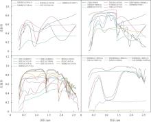
Fig.1
RELAB spectral data of igneous minerals, sulfates, secondary silicates, carbonates, oxides and basaltic glass extracted in this study"
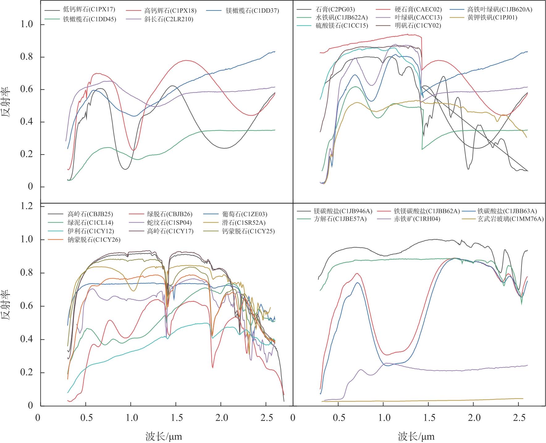
Table 2
Spectral range of the imaging spectral data selected in this study"
| 任务名称 | 载荷名称 | 谱段范围 |
|---|---|---|
| 天问一号 | MMS | 0.379 μm~1.076 μm |
| MRO | CRISM | 0.36 μm~1.05 μm |
| 1.0 μm~3.9 μm | ||
| 火星快车 | OMEGA | 0.38 μm~1.05 μm |
| 0.93 μm~2.73 μm |
Fig.2
Software Design of This Study"
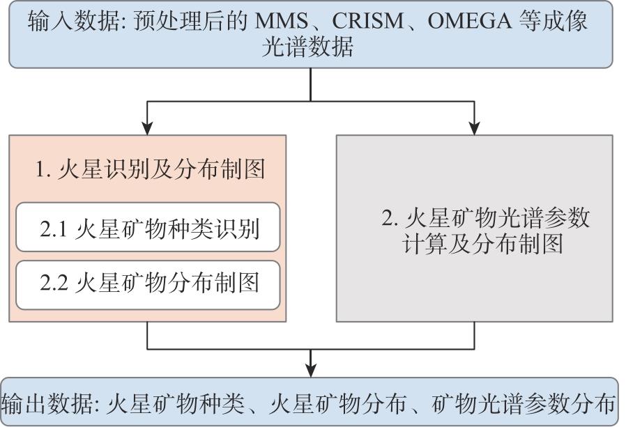
Table 3
The parameters of LCPINDEX, HCPINDEX, and OLINDEX"
| 光谱参数 | c | |||
|---|---|---|---|---|
| LCPINDEX | 1.56 | 2.45 | 1.69 | 0.2 |
| 1.75 | 0.2 | |||
| 1.81 | 0.3 | |||
| 1.87 | 0.2 | |||
| HCPINDEX | 1.69 | 2.50 | 2.12 | 0.1 |
| 2.14 | 0.1 | |||
| 2.23 | 0.15 | |||
| 2.25 | 0.3 | |||
| 2.43 | 0.2 | |||
| 2.46 | 0.15 | |||
| OLINDEX | 1.75 | 1.826 | 1.21 | 0.1 |
| 1.25 | 0.1 | |||
| 1.263 | 0.2 | |||
| 1.276 | 0.2 | |||
| 1.33 | 0.4 |
Table 4
The spectral parameters used in this work"
| 光谱参数 | 物质成分 | 分类 |
|---|---|---|
| BD_530 | 含铁氧化物、纳米相赤铁矿 | 赤铁矿 |
| BD_860 | 赤铁矿结晶状态 | 赤铁矿 |
| BD_640 | 磁铁矿 | 磁铁矿 |
| BD_920 | 低钙辉石 | 低钙辉石 |
| BD_2165 | Al-OH | Al-OH |
| BD_2190 | Al-OH | Al-OH |
| BD_2210 | Al-OH | Al-OH |
| BD_2250 | Al-OH和Si-OH | Al-OH |
| BD_2265 | 黄钾铁矾、水铝矿、酸性淋 滤绿脱石等 | 层状硅酸盐 |
| BD_2290 | Mg-OH、Fe-OH、干冰等 | 层状硅酸盐 |
| BD_2355 | 绿泥石、葡萄石等 | 层状硅酸盐 |
| MIN_2200 | 高岭石 | 层状硅酸盐 |
| MIN_2250 | 蛋白石 | 层状硅酸盐 |
| BD_1435 | 干冰 | 干冰 |
| BD_1330 | 斜长石中的Fe2+ | 火成矿物 |
| LCPINDEX | 低钙辉石 | 火成矿物 |
| HCPINDEX | 高钙辉石 | 火成矿物 |
| OLINDEX | 橄榄石 | 火成矿物 |
| BD_2100 | 单水硫酸盐中的H2O | 硫酸盐 |
| BD_2230 | 羟基硫酸铁 | 硫酸盐 |
| SINDEX | 含水硫酸盐 | 硫酸盐 |
| BD_1400 | H2O和-OH | 水/OH |
| BD_1750 | H2O | 水/OH |
| BD_1900 | H2O | 水/OH |
| BD_1500 | 水冰 | 水冰 |
| BD_2500 | Mg碳酸盐 | 碳酸盐 |
| MIN_2295_2480 | Mg碳酸盐 | 碳酸盐 |
| MIN_2345_2537 | Ca碳酸盐、Fe碳酸盐 | 碳酸盐 |
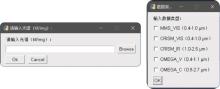
Fig.3
Interface of the software"
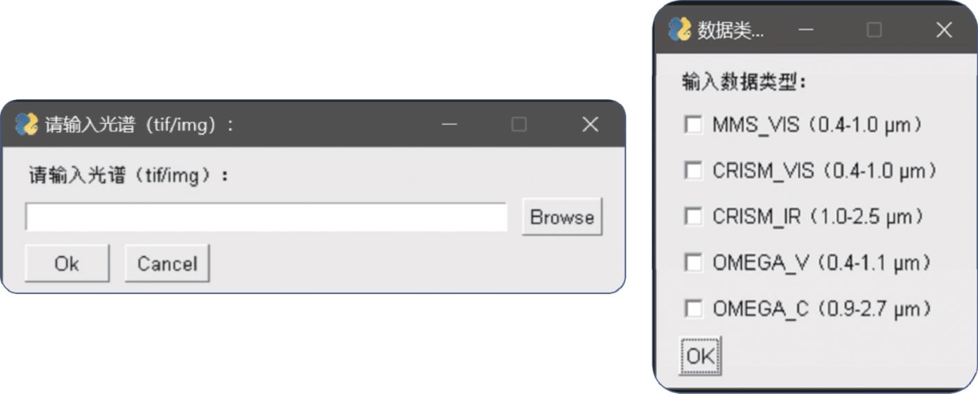
Table 5
The spectral imaging data selected in this work"
| 载荷名称 | 数据名称 | 谱段范围 |
|---|---|---|
| MMS | V_SCI_N_20220320132640_20220320135238_01004_A_sub_15.0_-10.0_Geo.png | 0.379 μm~1.076 μm |
| CRISM_S | hrl0000b8c2_07_if183s_trr3_corr_despike_p.img | 0.36 μm~1.05 μm |
| CRISM_L | hrl0000b8c2_07_if183l_trr3_CAT_corr_select_remove bad_destripe_despike_p.img | 1.0 μm~3.9 μm |
| OMEGA_V | orb0478_4.qub_V.IMG | 0.38 μm~1.05 μm |
| OMEGA_C | orb0478_4.qub_C_corr.IMG | 0.93 μm~2.73 μm |
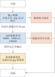
Fig.4
Software Operation Flowchart"

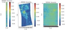
Fig.5
Quick view of mineral distribution based on MMS, CRISM, and OMEGA data"
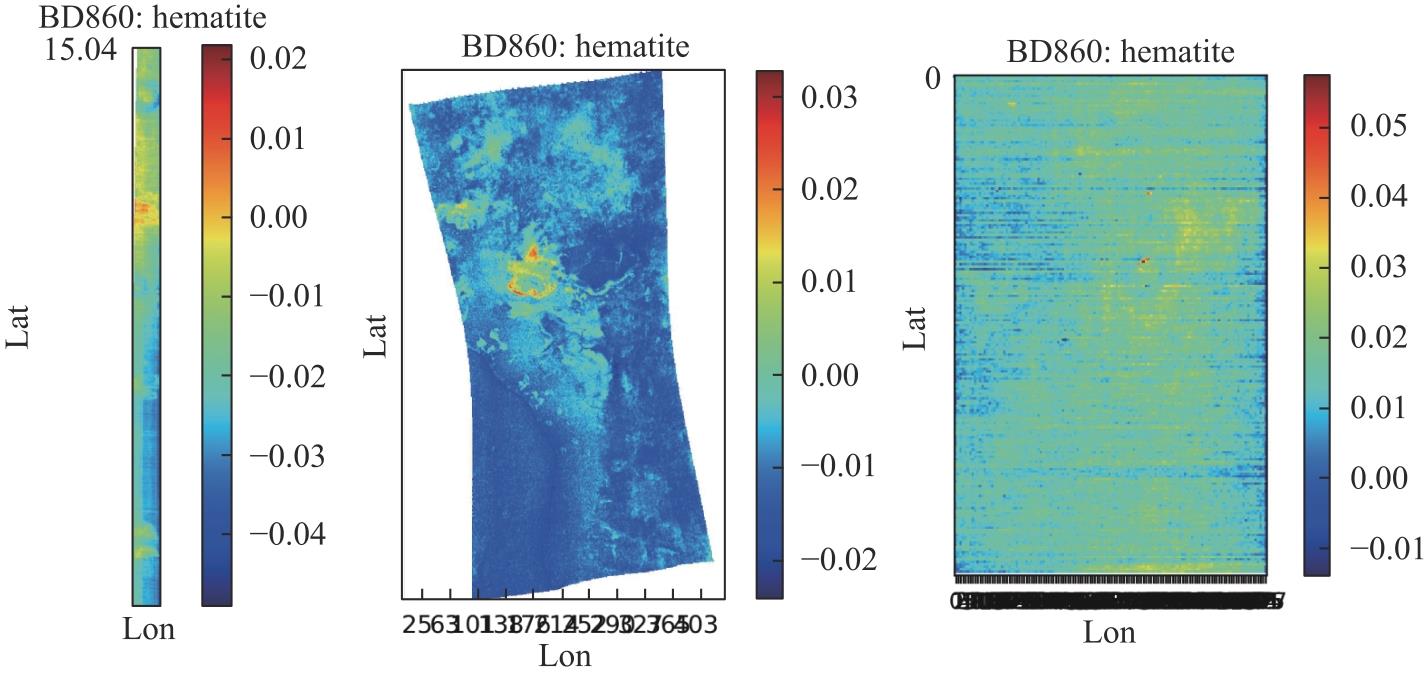
Table 6
Mineral identification results of the software based on five imaging spectral datasets"
| MMS | CRISM_S | CRISM_L | OMEGA_V | OMEGA_C | |||||||||
|---|---|---|---|---|---|---|---|---|---|---|---|---|---|
| 矿物 | RMSE | 矿物 | RMSE | 矿物 | RMSE | 矿物 | RMSE | 矿物 | RMSE | ||||
| 玄武岩玻璃 | 4.45E-05 | 玄武岩玻璃 | 1.40E-04 | 玄武岩玻璃 | 1.35E-04 | 玄武岩玻璃 | 2.52E-04 | 赤铁矿 | 5.53E-03 | ||||
| 葡萄石 | 1.06E-04 | 方解石 | 7.36E-04 | 赤铁矿 | 1.18E-03 | 硬石膏 | 2.19E-03 | 玄武岩玻璃 | 1.34E-02 | ||||
| 方解石 | 2.05E-04 | 硬石膏 | 7.40E-04 | 铁橄榄石 | 1.40E-03 | 石膏 | 2.54E-03 | 斜长石 | 1.52E-02 | ||||
| 镁碳酸盐 | 3.35E-04 | 葡萄石 | 7.93E-04 | 镁橄榄石 | 1.66E-03 | 葡萄石 | 5.27E-03 | 黄钾铁矾 | 1.81E-02 | ||||
| 硬石膏 | 3.85E-04 | 镁碳酸盐 | 9.62E-04 | 斜长石 | 2.22E-03 | 镁碳酸盐 | 6.27E-03 | 铁橄榄石 | 2.72E-02 | ||||
| 斜长石 | 4.65E-04 | 伊利石 | 1.18E-03 | 硬石膏 | 3.28E-03 | 伊利石 | 6.34E-03 | 高钙辉石 | 3.69E-02 | ||||
| 石膏 | 5.08E-04 | 斜长石 | 1.23E-03 | 黄钾铁矾 | 3.75E-03 | 镁橄榄石 | 6.78E-03 | 高岭石 | 4.38E-02 | ||||
| 滑石 | 5.58E-04 | 铁橄榄石 | 1.74E-03 | 水铁矾 | 5.52E-03 | 方解石 | 7.10E-03 | 硬石膏 | 4.64E-02 | ||||
| 高岭石 | 6.10E-04 | 镁橄榄石 | 1.75E-03 | 铁镁碳酸盐 | 6.02E-03 | 铁橄榄石 | 7.69E-03 | 叶绿矾 | 4.87E-02 | ||||
| 伊利石 | 6.12E-04 | 硫酸镁石 | 1.89E-03 | 伊利石 | 6.77E-03 | 硫酸镁石 | 8.12E-03 | 低钙辉石 | 4.94E-02 | ||||
Fig.6
The first four minerals identified based on MMS data and FATT method"
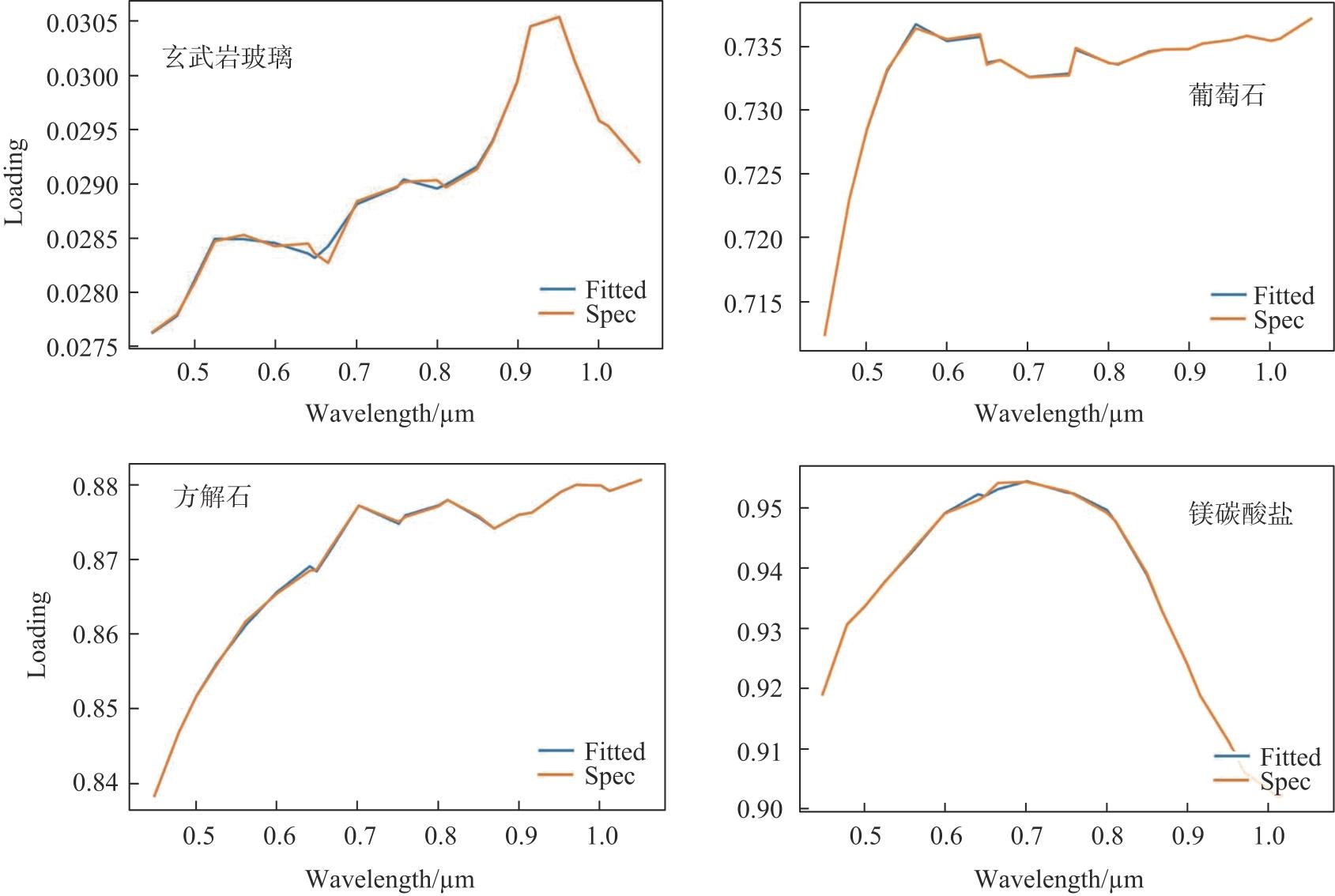
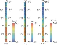
Fig.7
Distribution maps of SAM, SID and SID_SA parameters for Martian basaltic glass based on MMS data"
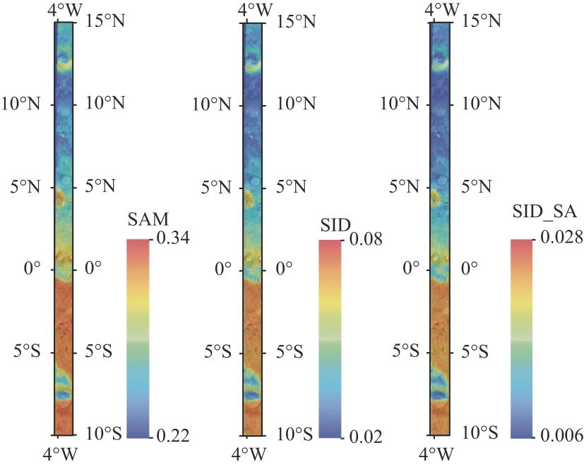
Fig.8
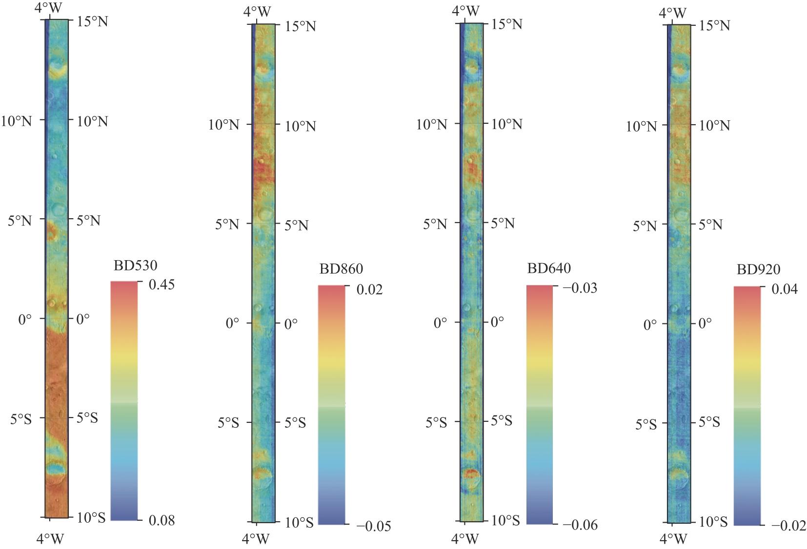
Distribution map of mineral spectral parameters based on MMS Data"
| [1] | CHRISTENSEN P, MCSWEEN H, BANDFIELD J, et al. Evidence for magmatic evolution and diversity on Mars from infrared observations[J]. Nature, 2005, 436(7050): 504-509. |
| [2] | BIBRING J P, LANGEVIN Y, GENDRIN A, et al. Mars surface diversity as revealed by the OMEGA/Mars Express observations[J]. Science, 2005, 307(5715): 1576-1581. |
| [3] | BIBRING J P, LANGEVIN Y, MUSTARD J F, et al. Global mineralogical and aqueous Mars history derived from OMEGA/Mars Express data[J]. Science, 2006, 312(5772): 400-404. |
| [4] | ARVIDSON R, SEELOS IV F, DEAL K, et al. Mantled and exhumed terrains in Terra Meridiani, Mars[J]. Journal of Geophysical Research: Planets, 2003, 108(E12): 8073. |
| [5] | ODY A, POULET F, BIBRING J P, et al. Global investigation of olivine on Mars: Insights into crust and mantle compositions[J]. Journal of Geophysical Research: Planets, 2013, 118(2): 234-262. |
| [6] | KOEPPEN W C, HAMILTON V E. Global distribution, composition, and abundance of olivine on the surface of Mars from thermal infrared data[J]. Journal of Geophysical Research: Planets, 2008, 113(E5): 001. |
| [7] | BUCZKOWSKI D L, MURCHIE S, CLARK R, et al. Investigation of an Argyre basin ring structure using Mars reconnaissance orbiter/compact reconnaissance imaging spectrometer for Mars[J]. Journal of Geophysical Research: Planets, 2010, 115(E12): 011. |
| [8] | KOUTSOVITIS P, MAGGANAS A, NTAFLOS T, et al. Rodingitization and carbonation, associated with serpentinization of Triassic ultramafic cumulates and lavas in Othris, Greece[J]. Lithos, 2018, 320: 35-48. |
| [9] | MUSTARD J F, MURCHIE S L, PELKEY S, et al. Hydrated silicate minerals on Mars observed by the Mars Reconnaissance Orbiter CRISM instrument[J]. Nature, 2008, 454(7202): 305-309. |
| [10] | MEUNIER A, PETIT S, EHLMANN B L, et al. Magmatic precipitation as a possible origin of Noachian clays on Mars[J]. Nature Geoscience, 2012, 5(10): 739-743. |
| [11] | CAWLEY J C, IRWIN III R P. Evolution of escarpments, pediments, and plains in the Noachian highlands of Mars[J]. Journal of Geophysical Research: Planets, 2018, 123(12): 3167-3187. |
| [12] | CHRISTENSEN P R, BANDFIELD J, CLARK R, et al. Detection of crystalline hematite mineralization on Mars by the Thermal Emission Spectrometer: Evidence for near-surface water[J]. Journal of Geophysical Research: Planets, 2000, 105(E4): 9623-9642. |
| [13] | CLARK B C, MORRIS R V, MCLENNAN S M, et al. Chemistry and mineralogy of outcrops at Meridiani Planum[J]. Earth and Planetary Science Letters, 2005, 240(1): 73-94. |
| [14] | ZOLOTOV M Y, MIRONENKO M V. Chemical models for martian weathering profiles: Insights into formation of layered phyllosilicate and sulfate deposits[J]. Icarus, 2016, 275: 203-220. |
| [15] | FLAHAUT J, CARTER J, POULET F, et al. Embedded clays and sulfates in Meridiani Planum, Mars[J]. Icarus, 2015, 248: 269-288. |
| [16] | MILLIKEN R E, BISH D L. Sources and sinks of clay minerals on Mars[J]. Philosophical Magazine, 2010, 90(17-18): 2293-2308. |
| [17] | WEITZ C M, MILLIKEN R, GRANT J A, et al. Mars Reconnaissance Orbiter observations of light-toned layered deposits and associated fluvial landforms on the plateaus adjacent to Valles Marineris[J]. Icarus, 2010, 205(1): 73-102. |
| [18] | LORENZO A, GARCíA-VICENTE A, MORALES J, et al. Spectral response (VNIR-SWIR) associated with the octahedral sheet of smectites[J]. Environmental Sciences Proceedings, 2021, 6(1): 23. |
| [19] | GHREFAT H, AL MUTAIRI Y, ELARABY H, et al. Using reflectance spectroscopy and Advanced Spaceborne Thermal Emission and Reflection Radiometer data to identify bauxite deposits in vicinity of Az Zabirah, northern Saudi Arabia[J]. Arabian Journal of Geosciences, 2021, 14(9): 820. |
| [20] | FARRAND W H, GLOTCH T D, HORGAN B. Detection of copiapite in the northern Mawrth Vallis region of Mars: Evidence of acid sulfate alteration[J]. Icarus, 2014, 241: 346-357. |
| [21] | FOX V, ARVIDSON R, GUINNESS E, et al. Smectite deposits in Marathon Valley, Endeavour Crater, Mars, identified using CRISM hyperspectral reflectance data[J]. Geophysical Research Letters, 2016, 43(10): 4885-4892. |
| [22] | FARRAND W H, GLOTCH T D, RICE JR J W, et al. Discovery of jarosite within the Mawrth Vallis region of Mars: Implications for the geologic history of the region[J]. Icarus, 2009, 204(2): 478-488. |
| [23] | LING Z, CAO F, NI Y, et al. Correlated analysis of chemical variations with spectroscopic features of the K-Na jarosite solid solutions relevant to Mars[J]. Icarus, 2016, 271: 19-29. |
| [24] | LIU C, LING Z, ZHANG J, et al. Laboratory Raman and VNIR spectroscopic studies of jarosite and other secondary mineral mixtures relevant to Mars[J]. Journal of Raman Spectroscopy, 2020, 51(9): 1575-1588. |
| [25] | HUGHES E, WRAY J, RIVERA-HERNáNDEZ F, et al. Raman and VNIR Spectra of Sri Lanka Serpentine Zone Minerals with Relevance to Nile Fossae and Jezero Crater, Mars[M]. 55th Lunar and Planetary Science Conference. 2024: 2303. |
| [26] | LIU W P, YIN W, YE B L, et al. Reliable spectroscopic identification of minerals associated with serpentinization: Relevance to Mars exploration[J]. Icarus, 2023, 394: 115440. |
| [27] | HONG D X, LIU C Z, LIN H L, et al. Near-infrared spectral characterization of the abyssal serpentinites and its implications for Martian exploration[J]. Lithos, 2025, 508-509: 108077. |
| [28] | EHLMANN B L, MUSTARD J F, MURCHIE S L. Geologic setting of serpentine deposits on Mars[J]. Geophysical Research Letters, 2010, 37(6): 53-67. |
| [29] | EMRAN A, TARNAS J D, STACK K M. Global Distribution of Serpentine on Mars[J]. Geophysical Research Letters, 2025, 52(2): e2024GL110630. |
| [30] | TARNAS J, STACK K, PARENTE M, et al. Characteristics, origins, and biosignature preservation potential of carbonate-bearing rocks within and outside of Jezero crater[J]. Journal of Geophysical Research: Planets, 2021, 126(11): e2021JE006898. |
| [31] | HARNER P L, GILMORE M S. Visible-near infrared spectra of hydrous carbonates, with implications for the detection of carbonates in hyperspectral data of Mars[J]. Icarus, 2015, 250: 204-214. |
| [32] |
EHLMANN B L, MUSTARD J F, MURCHIE S L, et al. Orbital Identification of Carbonate-Bearing Rocks on Mars[J]. Science, 2008, 322(5909): 1828-1832.
doi: 10.1126/science.1164759 pmid: 19095939 |
| [33] | HE Z, XU R, LI C, et al. Mars mineralogical spectrometer (MMS) on the Tianwen-1 mission[J]. Space Science Reviews, 2021, 217: 1-36. |
| [34] | MURCHIE S, ARVIDSON R, BEDINI P, et al. Compact reconnaissance imaging spectrometer for Mars (CRISM) on Mars reconnaissance orbiter (MRO)[J]. Journal of Geophysical Research: Planets, 2007, 112(E5): S03. |
| [35] | BIBRING J P, SOUFFLOT A, BERTHé M, et al. OMEGA: Observatoire pour la Minéralogie, l’Eau, les Glaces et l’Activité[M]. Mars Express: the scientific payload. City, 2004: 37-49. |
| [36] | ODY A, POULET F, LANGEVIN Y, et al. Global maps of anhydrous minerals at the surface of Mars from OMEGA/MEx[J]. Journal of Geophysical Research: Planets, 2012, 117: E00J14 |
| [37] | FIGUERA R M, HUU B P, ROSSI A P, et al. Online characterization of planetary surfaces: PlanetServer, an open-source analysis and visualization tool[J]. Planetary Space Science, 2018, 150: 141-156. |
| [38] | SARANATHAN A M, PARENTE M. Adversarial feature learning for improved mineral mapping of CRISM data[J]. Icarus, 2021, 355: 114107. |
| [39] | AMADOR E S, BANDFIELD J L, THOMAS N H. A search for minerals associated with serpentinization across Mars using CRISM spectral data[J]. Icarus, 2018, 311: 113-134. |
| [40] | PLEBANI E, EHLMANN B L, LEASK E K, et al. A machine learning toolkit for CRISM image analysis[J]. Icarus, 2022, 376: 114849. |
| [41] | COMBE J P, LE MOUéLIC S, SOTIN C, et al. Analysis of OMEGA/Mars Express data hyperspectral data using a Multiple-Endmember Linear Spectral Unmixing Model (MELSUM): Methodology and first results[J]. Planetary and Space Science, 2008, 56(7): 951-975. |
| [42] | MOUSSAOUI S, HAUKSDóTTIR H, SCHMIDT F, et al. On the decomposition of Mars hyperspectral data by ICA and Bayesian positive source separation[J]. Neurocomputing, 2008, 71(10): 2194-2208. |
| [43] | LIN H, TARNAS J D, MUSTARD J F, et al. Dynamic aperture factor analysis/target transformation (DAFA/TT) for Mg-serpentine and Mg-carbonate mapping on Mars with CRISM near-infrared data[J]. Icarus, 2021, 355: 114168. |
| [44] | BANDFIELD J L, CHRISTENSEN P R, SMITH M D. Spectral data set factor analysis and end-member recovery: Application to analysis of Martian atmospheric particulates[J]. Journal of Geophysical Research Planets, 2000, 105(E4): 9573-9587. |
| [45] | VIVIANO-BECK C E, SEELOS F P, MURCHIE S L, et al. Revised CRISM spectral parameters and summary products based on the currently detected mineral diversity on Mars[J]. Journal of Geophysical Research: Planets, 2014, 119(6): 1403-1431. |
| [46] | NOE DOBREA E, WRAY J, CALEF III F, et al. Hydrated minerals on Endeavour Crater’s rim and interior, and surrounding plains: New insights from CRISM data[J]. Geophysical Research Letters, 2012, 39(23): L23201. |
| [47] | BELL J F, MORRIS R V, ADAMS J B. Thermally altered palagonitic tephra: A spectral and process analog to the soil and dust of Mars[J]. Journal of Geophysical Research: Planets, 1993, 98(E2): 3373-3385. |
| [48] | MORRIS R V, GOLDEN D C, BELL J F, et al. Mineralogy, composition, and alteration of Mars Pathfinder rocks and soils: Evidence from multispectral, elemental, and magnetic data on terrestrial analogue, SNC meteorite, and Pathfinder samples[J]. Journal of Geophysical Research: Planets, 2000, 105(E1): 1757-1817. |
| [49] | FARRAND W H, BELL J F, JOHNSON J R, et al. Spectral variability among rocks in visible and near-infrared multispectral Pancam data collected at Gusev crater: Examinations using spectral mixture analysis and related techniques[J]. Journal of Geophysical Research: Planets, 2006, 111(E2): S15. |
| [50] | POULET F, GOMEZ C, BIBRING J P, et al. Martian surface mineralogy from Observatoire pour la Mineralogie, l’Eau, les Glaces et l’Activite on board the Mars Express spacecraft (OMEGA/MEx): Global mineral maps[J]. Journal of Geophysical Research: Planets, 2007, 112(E8): S02. |
| [51] | BELL J F, MCSWEEN H Y, CRISP J A, et al. Mineralogic and compositional properties of Martian soil and dust: Results from Mars Pathfinder[J]. Journal of Geophysical Research: Planets, 2000, 105(E1): 1721-1755. |
| [1] | LIU Yangxiaoyue, YANG Yaping. Progress on Large-Scale Soil Moisture Products by Fusion of Multi-Source Microwave Remote Sensing Datasets: a Review [J]. Frontiers of Data and Computing, 2023, 5(5): 119-127. |
| [2] | MENG Xianghai,WANG Xuezhi,ZHAO Jianghua,ZHOU Xiaohua. A Lightweight Remote Sensing Data Distributed Scheduling Framework DataboxMR [J]. Frontiers of Data and Computing, 2021, 3(3): 95-110. |
| [3] | ZHAO Weiyu,ZHANG Honghai,ZHONG Bo. A Deep Learning Based Method for Remote Sensing Image Parcel Segmentation [J]. Frontiers of Data and Computing, 2021, 3(2): 133-141. |
| [4] | Wang Wensheng,Guo Leifeng. Big Data Technology Applications in Agriculture [J]. Frontiers of Data and Computing, 2020, 2(2): 101-110. |
| Viewed | ||||||
|
Full text |
|
|||||
|
Abstract |
|
|||||