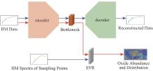
| [1] |
GHASSEMIAN H. A review of remote sensing image fusion methods[J]. Information Fusion, 2016, 32: 75-89.
|
| [2] |
CORLEY L M, MCGOVERN P J, KRAMER G Y, et al. Olivine-bearing lithologies on the Moon: Constraints on origins and transport mechanisms from M3 spectroscopy, radiative transfer modeling, and GRAIL crustal thickness[J]. Icarus, 2018, 300: 287-304.
|
| [3] |
BISHOP J L, GROSS C, DANIELSEN J, et al. Multiple mineral horizons in layered outcrops at Mawrth Vallis, Mars, signify changing geochemical environments on early Mars[J]. Icarus, 2020, 341: 113634.
|
| [4] |
FA W, JIN Y Q. A primary analysis of microwave brightness temperature of lunar surface from Chang-E 1 multi-channel radiometer observation and inversion of regolith layer thickness[J]. Icarus, 2010, 207(2): 605-615.
|
| [5] |
NICKERSON R D, BART G D, LAWDER M T, et al. GLOBAL LUNAR REGOLITH DEPTHS REVEALED[J]. 42nd Lunar and Planetary Science Conference, 2011: 2607.
|
| [6] |
DI K, SUN S, YUE Z, et al. Lunar regolith thickness determination from 3D morphology of small fresh craters[J]. Icarus, 2016, 267: 12-23.
|
| [7] |
YUE Z, DI K, LIU Z, et al. Lunar regolith thickness deduced from concentric craters in the CE-5 landing area[J]. Icarus, 2019, 329: 46-54.
|
| [8] |
VENKATRAMAN J, HORVATH T, POWELL T M, et al. Statistical estimates of rock-free lunar regolith thickness from diviner[J]. Planetary and Space Science, 2023, 229: 105662.
|
| [9] |
ZHIGUO M, YI X, ZHANCHUAN C, et al. Influence of lunar topography on simulated surface temperature[J]. Advances in Space Research, 2014, 54(10): 2131-2139.
|
| [10] |
WANG R, SU Y, DING C, et al. A Novel Approach for Permittivity Estimation of Lunar Regolith Using the Lunar Penetrating Radar Onboard Chang’E-4 Rover[J]. 2021, 13(18): 3679.
|
| [11] |
FA W, ZHU M H, LIU T, et al. Regolith stratigraphy at the Chang’E-3 landing site as seen by lunar penetrating radar[J]. Geophysical Research Letters, 2015, 42(23): 179-187.
|
| [12] |
CAMPBELL B A, HAWKE B R, THOMPSON T W. Regolith composition and structure in the lunar maria: Results of long-wavelength radar studies[J]. J. Geophys. Res., 1997, 102(E8): 19307-19320.
|
| [13] |
SHKURATOV Y. Regolith Layer Thickness Mapping of the Moon by Radar and Optical Data[J]. Icarus, 2001, 149(2): 329-338.
|
| [14] |
LAI J, XU Y, ZHANG X, et al. Comparison of Dielectric Properties and Structure of Lunar Regolith at Chang’e-3 and Chang’e-4 Landing Sites Revealed by Ground-Penetrating Radar[J]. Geophysical Research Letters, 2019, 46(22): 12783-12793.
|
| [15] |
HELFENSTEIN P, SHEPARD M K. Submillimeter-scale topography of the lunar regolith[J]. Icarus, 1999, 141(1): 107-131.
|
| [16] |
GUO D, FA W, WU B, et al. Millimeter- to Decimeter-Scale Surface Roughness of the Moon at the Chang’e-4 Exploration Region[J]. Geophysical Research Letters, 2021, 48(19): e2021GL094931.
|
| [17] |
OROSEI R, BIANCHI R, CORADINI A, et al. Self-affine behavior of Martian topography at kilometer scale from Mars Orbiter Laser Altimeter data[J]. J Geophys Res Planets, 2003, 108(E4).
|
| [18] |
KRESLAVSKY M A, HEAD J W. North-south topographic slope asymmetry on Mars: Evidence for insolation-related erosion at high obliquity[J]. Geophys Res Lett, 2003, 30(15): 1815.
|
| [19] |
KRESLAVSKY M A, HEAD J W, NEUMANN G A, et al. Lunar topographic roughness maps from Lunar Orbiter Laser Altimeter (LOLA) data: Scale dependence and correlation with geologic features and units[J]. Icarus, 2013, 226(1): 52-66.
|
| [20] |
LI B, ZHANG J, YUE Z, et al. Deriving terrain factors from high-resolution lunar images: A case study of the Mons Rümker Region[J]. Geomorphology, 2020, 358.
|
| [21] |
WU B, DONG J, WANG Y, et al. Landing Site Selection and Characterization of Tianwen-1 (Zhurong Rover) on Mars[J]. J Geophys Res Planets, 2022, 127(4).
|
| [22] |
DELATTE D M, CRITES S T, GUTTENBERG N, et al. Automated crater detection algorithms from a machine learning perspective in the convolutional neural network era[J]. Advances in Space Research, 2019, 64(8): 1615-1628.
|
| [23] |
CHRISTIAN J A, DERKSEN H, WATKINS R. Lunar Crater Identification in Digital Images[J]. J Astronaut Sci, 2021, 68(4): 1056-144.
doi: 10.1007/s40295-021-00287-8
pmid: 35001965
|
| [24] |
LEE C. Automated crater detection on Mars using deep learning[J]. Planet Space Science, 2019.
|
| [25] |
FAIRWEATHER J, LAGAIN A, SERVIS K, et al. Using an Automated Crater Detection Algorithm as a Tool for Mapping Secondary Crater Clusters on the Moon: Chang’E 5 Landing Site[J]. LPI Contributions, 2022, 2678: 1925.
|
| [26] |
RUBANENKO L, PéREZ-LóPEZ S, SCHULL J, et al. Automatic Detection and Segmentation of Barchan Dunes on Mars and Earth Using a Convolutional Neural Network[J]. IEEE Journal of Selected Topics in Applied Earth Observations and Remote Sensing, 2021, 14: 9364-9371.
|
| [27] |
WANG Y, WU B. Active Machine Learning Approach for Crater Detection From Planetary Imagery and Digital Elevation Models[J]. IEEE Transactions on Geoscience and Remote Sensing, 2019, 57(8): 5777-5789.
|
| [28] |
NEUKUM G, IVANOV B A, HARTMANN W K. Cratering Records in the Inner Solar System in Relation to the Lunar Reference System[J]. Space Science Reviews, 2001, 96(1): 55-86.
|
| [29] |
LAGAIN A, SERVIS K, BENEDIX G K, et al. Model Age Derivation of Large Martian Impact Craters, Using Automatic Crater Counting Methods[J]. Earth and Space Science, 2021, 8(2): e2020EA001598.
|
| [30] |
ANG C, ZHAO H, BRUZZONE L, et al. Lunar impact crater identification and age estimation with Chang’E data by deep and transfer learning[J]. Nat Commun, 2020, 11(1): 6358.
|
| [31] |
YANG H, XU X, MA Y, et al. CraterDANet: A Convolutional Neural Network for Small-Scale Crater Detection via Synthetic-to-Real Domain Adaptation[J]. IEEE Transactions on Geoscience and Remote Sensing, 2022, 60: 1-12.
|
| [32] |
刘丹, 甘红, 魏广飞, 等. 基于光照和坡度约束的月球南极着陆选址分析[J]. 深空探测学报(中英文), 2023, 10(5): 544-556.
|
| [33] |
LEMELIN M, LUCEY P G, CAMON A. Compositional Maps of the Lunar Polar Regions Derived from the Kaguya Spectral Profiler and the Lunar Orbiter Laser Altimeter Data[J]. The Planetary Science Journal, 2022, 3(3): 63.
|
| [34] |
凌宗成, 张江, 刘建忠, 等. 嫦娥一号干涉成像光谱仪数据再校正与全月铁钛元素反演[J]. 岩石学报, 2016, 32(1): 87-98.
|
| [35] |
WANG Y, CAO H, CHEN J, et al. New maps of mafic mineral abundances in global mare units on the Moon[J]. ISPRS Journal of Photogrammetry and Remote Sensing, 2025, 224: 348-360.
|
| [36] |
WEI G, LI X, GAN H, et al. Retrieval of lunar polar heat flow from Chang’E-2 microwave radiometer and Diviner observations[J]. Frontiers in Astronomy and Space Sciences, 2023, 10: 1179558.
|
| [37] |
GAN H, ZHAO C, WEI G, et al. Numerical Simulation of the Lunar Polar Environment: Implications for Rover Exploration Challenge[J]. Aerospace, 2023, 10(7): 598.
|
| [38] |
WEI G, LI X, ZHANG W, et al. Illumination conditions near the Moon’s south pole: Implication for a concept design of China’s Chang’E-7 lunar polar exploration[J]. Acta Astronautica, 2023, 208: 74-81.
|
| [39] |
GAN H, WEI G, ZHANG X, et al. Experimental study on electrostatic migration of different mineral particles composing lunar dust under electron irradiation[J]. Frontiers in Astronomy and Space Sciences, 2023, 10: 1213294.
|
| [40] |
GAN H, WEI G, ZHANG W, et al. Lunar polar illumination and electrical field environment simulation based on a conceptual design for China’ s Chang’ E-7 mission[J]. SCIENTIA SINICA Physica, Mechanica & Astronomica, 2023, 53(4): 24 9611.
|
| [41] |
YANG W, HU G, YANG F, et al. Inversion of the Lunar Subsurface Rock Abundance Using CE-2 Microwave Brightness Temperature Data[J]. Remote Sensing, 2023, 15(20): 4895.
|
| [42] |
LI J, CHEN Y, ZENG Z. Estimated Lunar Regolith Structure Based on the Least-Squares Kirchhoff Migration of CE-3 Lunar Penetrating Radar Data[J]. IEEE Geoscience and Remote Sensing Letters, 2021, 18(5): 816-820.
|
| [43] |
LI B, QU S, LING Z, et al. A Preliminary Study on the Identification and Spatio-Temporal Characteristics of Martian Atmospheric Eddies[J]. Journal of Geophysical Research: Planets, 2024, 129(2): e2023JE00 7937.
|
| [44] |
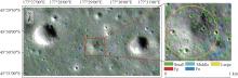
YANG Y, WANG Y, LI B, et al. Variation of crater morphological parameters in the landing area of Tianwen-1: relationships with the geological environment and climate change[J]. Earth, Planets and Space, 2024, 76(1): 19.
|
| [45] |
GUO D, BAO Y, LIU Y, et al. Geological investigation of the lunar Apollo basin: From surface composition to interior structure[J]. Earth and Planetary Science Letters, 2024, 646: 118986.
|
 ),LI Bo1,WEI Guangfei2,3,GUO Dijun4,LYU Yingbo1,LIU Changqing1,ZHU Kai2,CHEN Jian1,ZHAO Qiang5,LI Jing6,HU Guoping7,WANG Jiao8,LIU Jianzhong2